1960s Maps of Okmulgee County, Oklahoma
Explore 6 historic maps of Okmulgee County from the 1960s. These maps offer a rare glimpse into what life looked like during the 1960s — showing old roads, neighborhoods, homes, and landmarks that have changed or disappeared over time.
Whether you're researching your family's past, planning a metal detecting trip, or studying how Okmulgee County's landscape evolved across the 1960s, these high-resolution maps are a powerful tool for exploring the history of this region.
- Focus on a specific era: All maps on this page are from the 1960s, giving you a focused view of this time period.
- See what’s changed: Compare century-old streets, trails, and buildings to today's modern landscape using overlays and satellite layers.
- Research with precision: Use these maps for genealogy, historical research, land use analysis, or educational projects.
- View, download, or print: Maps are fully viewable online in high resolution, and can be downloaded or printed for your own records.
Start exploring Okmulgee County's history through authentic maps from the 1960s. This is your window into the past.
Okmulgee County, OK maps
(6)- 1962 Map of Henryetta, 1963 Print
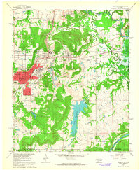 1962 Henryetta1963 Print · USGSHenryetta and its surrounding rail junctions are captured here in the early sixties as the landscape prepared for the creation of Eufaula Reservoir. Researchers can trace historic industrial sites like the Smelter and small communities such as Spelter City, Dewar, and Kusa.4 unique versions available
 - 1962 Map of Hoffman, 1964 Print
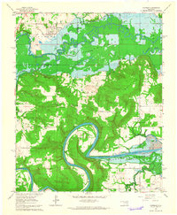 1962 Hoffman1964 Print · USGSThe Okmulgee and McIntosh county line is captured here in the early sixties as the reservoir began to transform the river valley. Genealogists can trace family landmarks like Morrison Cemetery, Tiger Mountain School, and the settlement of Lenna.2 unique versions available
 - 1963 Map of Oklahoma City
 1963 Oklahoma City1963 Print · USGSCentral Oklahoma in the early sixties showcases a landscape of rapid suburban growth and established oil production. Researchers can trace historic rail lines like the Chicago Rock Island and Pacific RR or locate rural landmarks such as Mayflower School and Bethel Church.
 - 1965 Map of Fort Smith
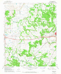
 1965 Fort Smith1965 Print · USGSEastern Oklahoma and Western Arkansas are captured here during a period of massive post-war change as new reservoirs reshaped the river valleys. Genealogists and historians can trace the rail networks of the Midland Valley RR and find established communities like Stilwell, Sallisaw, and Stigler.
 - 1967 Map of Fort Smith
 1967 Fort Smith1967 Print · USGSThe Arkansas River valley and the foothills of the Ozarks are captured here during a period of significant military and industrial activity. Researchers can trace the sprawling bounds of Camp Chaffee and Camp Gruber or locate vanished rail stops along the Midland Valley RR.
 - 1967 Map of Pharoah, 1968 Print
 1967 Pharoah1968 Print · USGSThe Oklahoma oil fields west of Henryetta are captured here during the late sixties, showcasing a landscape defined by petroleum extraction and rail transport. Genealogists can trace family locations through numerous sites like West Lawn Cemetery, Arbeka Ch, and the settlement at Pharoah.2 unique versions available
End of results
Showing maps 1-6 of 6
Top cities of Okmulgee County
- Okmulgee historical maps
- Henryetta historical maps
- Beggs historical maps
- Morris historical maps
- Dewar historical maps
- Schulter historical maps
See more
Frequently asked questions
- What are the different types of historical maps available for Okmulgee County?
- What is the oldest map of Okmulgee County?
- Where can I purchase historical maps of Okmulgee County for my home or office?
- Where can I download high-res historical maps of Okmulgee County?
- Are there historical topographic maps available for Okmulgee County?
- Is there historical aerial imagery available for Okmulgee County?
- Where are historical maps of Okmulgee County sourced from?