1970s Maps of Grayson, Oklahoma
Explore 5 historic maps of Grayson from the 1970s. These maps offer a rare glimpse into what life looked like during the 1970s — showing old roads, neighborhoods, homes, and landmarks that have changed or disappeared over time.
Whether you're researching your family's past, planning a metal detecting trip, or studying how Grayson's landscape evolved across the 1970s, these high-resolution maps are a powerful tool for exploring the history of this region.
- Focus on a specific era: All maps on this page are from the 1970s, giving you a focused view of this time period.
- See what’s changed: Compare century-old streets, trails, and buildings to today's modern landscape using overlays and satellite layers.
- Research with precision: Use these maps for genealogy, historical research, land use analysis, or educational projects.
- View, download, or print: Maps are fully viewable online in high resolution, and can be downloaded or printed for your own records.
Start exploring Grayson's history through authentic maps from the 1970s. This is your window into the past.
Grayson, OK maps
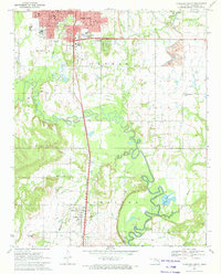
(5)- 1970 Map of Morris, 1972 Print
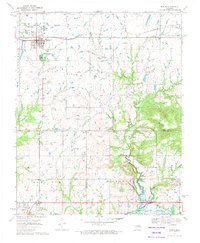 1970 Morris1972 Print · USGSEastern Oklahoma at the start of the 1970s reveals a landscape shaped by petroleum and rail. Genealogists and historians can trace family locations near Morris and Grayson, or locate historic sites like Indian Cem and the Grave Creek Ch.
 - 1971 Map of Okmulgee South, 1972 Print
 1971 Okmulgee South1972 Print · USGSOklahoma's Okmulgee County is captured here in the early seventies, showing a landscape defined by the Deep Fork bottomlands and active oil fields. Genealogists can trace the rural communities around Schulter, noting landmarks like Big Cussetah Ch and Pawhuska Cem.
 - 1978 Map of Eufaula, 1979 Print
 1978 Eufaula1979 Print · USGSEastern Oklahoma in the late seventies is defined by the sprawling waters of Eufaula Lake and the dense timber of the Sans Bois Mountains. Genealogists and historians can trace the development of towns like Checotah and Stigler or locate legacy sites like the Old R R Grade and Robbers Cave State Park.
 - 1978 Map of Muskogee, 1979 Print
 1978 Muskogee1979 Print · USGSThe confluence of the Arkansas, Verdigris, and Neosho Rivers defines the Muskogee region in the late seventies. Genealogists and historians can trace the footprints of Camp Gruber (Abandoned), the campus of Bacone College, and early aviation at Hatbox Field.
 - 1978 Map of Fort Smith, 1979 Print
 1978 Fort Smith1979 Print · USGSThe Arkansas-Oklahoma borderlands in the late seventies show a landscape shaped by massive river reservoirs and sprawling military reservations. Trace the historic rail lines of the Missouri Pacific RR and locate regional landmarks like Fort Gibson, Tenkiller Ferry Lake, and Barling.2 unique versions available
End of results
Showing maps 1-5 of 5
Top cities near Grayson
- Okmulgee historical maps
- Henryetta historical maps
- Beggs historical maps
- Morris historical maps
- Dewar historical maps
- Schulter historical maps
See more
Frequently asked questions
- What are the different types of historical maps available for Grayson?
- What is the oldest map of Grayson?
- Where can I purchase historical maps of Grayson for my home or office?
- Where can I download high-res historical maps of Grayson?
- Are there historical topographic maps available for Grayson?
- Is there historical aerial imagery available for Grayson?
- Where are historical maps of Grayson sourced from?