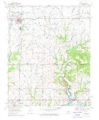
1970 Map of Morris
USGS Topo · Published 1972About this map
Morris Oil Field dominates the central landscape of this Oklahoma survey, highlighting an era when petroleum extraction defined the local economy alongside the St Louis - San Francisco railroad. The settlement of Morris serves as the primary hub, while smaller communities like Grayson, Hitchita, and Eram are documented with their surrounding sections of the Okmulgee and McIntosh county line. Genealogical value is high throughout the quadrangle, with several distinct burial grounds including Morris Cem, Indian Cem, and Sacred Heart Cem mapped in detail. To the southeast, the terrain transitions toward the banks of the Eufaula Reservoir, where the drainage of Grave Creek and Cussetah Creek meet the rising waters. This document captures the intersection of industrial land use, from numerous oil wells and gas wells to the traditional rural infrastructure of churches and community cemeteries.
Find a feature on this map
29 named features on this map. Tap any name to fly to it.
Don’t see what you’re looking for? This feature index may not catch every label — zoom into the map to look around manually.
Map Details
Editions of this 1970 Morris Map
This is the sole edition of this map. No revisions or reprints were ever made.
Other maps of this area

1896 · Okmulgee
USGS Topo · 1:125,000

1900 · Canadian
USGS Topo · 1:125,000

1900 · Okmulgee
USGS Topo · 1:125,000

1946 · Fort Smith
USGS Topo · 1:250,000

1962 · Henryetta
USGS Topo · 1:24,000

1962 · Pierce
USGS Topo · 1:24,000

1962 · Hoffman
USGS Topo · 1:24,000

1965 · Fort Smith
USGS Topo · 1:250,000

1967 · Fort Smith
USGS Topo · 1:250,000
1970 · Council Hill
USGS Topo · 1:24,000