1900s (20th Century) Maps of Miami, Oklahoma
Explore 10 historic maps of Miami from the 1900s (20th Century). These maps offer a rare glimpse into what life looked like during the 1900s — showing old roads, neighborhoods, homes, and landmarks that have changed or disappeared over time.
Whether you're researching your family's past, planning a metal detecting trip, or studying how Miami's landscape evolved across the 1900s, these high-resolution maps are a powerful tool for exploring the history of this region.
- Focus on a specific era: All maps on this page are from the 1900s, giving you a focused view of this time period.
- See what’s changed: Compare century-old streets, trails, and buildings to today's modern landscape using overlays and satellite layers.
- Research with precision: Use these maps for genealogy, historical research, land use analysis, or educational projects.
- View, download, or print: Maps are fully viewable online in high resolution, and can be downloaded or printed for your own records.
Start exploring Miami's history through authentic maps from the 1900s. This is your window into the past.
Miami, OK maps
(10)- 1907 Map of Wyandotte, 1954 Print
 1907 Wyandotte1954 Print · USGSThe Tri-State border region at the start of the twentieth century shows a landscape of river ferries and early rail towns. Trace the locations of family landmarks like Hickory Grove Church, Goad Eagle Ferry, and rural schools from Afton to Seneca.2 unique versions available
 - 1909 Map of Wyandotte
 1909 Wyandotte1909 Print · USGSNortheastern Oklahoma’s river valleys and prairies are captured here just after statehood, during a period of rapid rail expansion and tribal land transition. Researchers can trace early river crossings like Rodwhite Ferry and locate historic community centers such as Hickory Grove Church or the Bluejacket School.2 unique versions available
 - 1954 Map of Tulsa
 1954 Tulsa1954 Print · USGSNortheast Oklahoma and the Ozark border are shown here during a period of massive industrial and infrastructure growth. Researchers can trace the legacy of the Tri-State Mining District and the development of major reservoirs like Grand Lake O' The Cherokees.2 unique versions available
 - 1958 Map of Tulsa, 1968 Print
 1958 Tulsa1968 Print · USGSNortheast Oklahoma and the Ozark borderlands are captured here during a massive era of reservoir construction and highway expansion. Researchers can trace the mid-century footprints of Tulsa, the sprawling Lake O' the Cherokees, and historical sites like Pea Ridge National Military Park.3 unique versions available
 - 1961 Map of Miami SE, 1962 Print
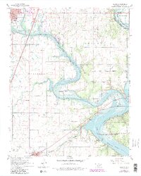 1961 Miami SE1962 Print · USGSNortheastern Oklahoma at the turn of the sixties shows a landscape shaped by tribal boundaries and the waters of the Lake of the Cherokees. Trace family roots at Bland Cem or locate former schools like McKinley Sch.4 unique versions available
 - 1961 Map of Miami NW, 1963 Print
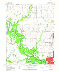 1961 Miami NW1963 Print · USGSNortheastern Oklahoma at the start of the 1960s shows a landscape defined by tribal heritage and the legacy of the Tri-State mining district. Genealogists and historians can trace Old Indian Cem and North Fairview Sch alongside the active tracks of the St Louis-San Francisco RR.2 unique versions available
 - 1961 Map of Miami SW, 1963 Print
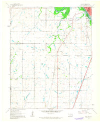 1961 Miami SW1963 Print · USGSSouthwest of Miami in the early sixties, the landscape reflects a shift from rail-side settlements to turnpike travel. Local researchers can trace family landmarks like Lone Star Ch, Coal Creek Cem, and the small community of Narcissa.2 unique versions available
 - 1961 Map of Picher, 1963 Print
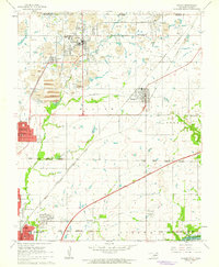 1961 Picher1963 Print · USGSOttawa County mining towns and tribal lands are captured here in the early sixties, as the lead and zinc industry shaped the landscape. Researchers can trace the industrial footprints of Century (Douthat PO) and Treece or locate family roots at Peery Cem.2 unique versions available
 - 1963 Map of Tulsa
 1963 Tulsa1963 Print · USGSThe Oklahoma and Arkansas borderlands are shown here in the early sixties, a time of massive reservoir construction and heavy mining. Genealogists can trace family roots through settlements like Nowata, Pryor, and Jay, or locate historical zinc and lead mines and coal mines.
 - 1986 Map of Neosho
 1986 Neosho1986 Print · USGSThe tri-state border region comes alive in the mid-eighties as a landscape of mining heritage and river valleys. Researchers can trace the rail lines of the Kansas City Southern Ry and locate rural landmarks like Gibson Cem and Peoria.2 unique versions available
End of results
Showing maps 1-10 of 10
Top cities near Miami
- Baxter Springs historical maps
- Galena historical maps
- Commerce historical maps
- Chetopa historical maps
- Afton historical maps
- Fairland historical maps
See more
Frequently asked questions
- What are the different types of historical maps available for Miami?
- What is the oldest map of Miami?
- Where can I purchase historical maps of Miami for my home or office?
- Where can I download high-res historical maps of Miami?
- Are there historical topographic maps available for Miami?
- Is there historical aerial imagery available for Miami?
- Where are historical maps of Miami sourced from?