1960s Maps of Pawnee County, Oklahoma
Explore 3 historic maps of Pawnee County from the 1960s. These maps offer a rare glimpse into what life looked like during the 1960s — showing old roads, neighborhoods, homes, and landmarks that have changed or disappeared over time.
Whether you're researching your family's past, planning a metal detecting trip, or studying how Pawnee County's landscape evolved across the 1960s, these high-resolution maps are a powerful tool for exploring the history of this region.
- Focus on a specific era: All maps on this page are from the 1960s, giving you a focused view of this time period.
- See what’s changed: Compare century-old streets, trails, and buildings to today's modern landscape using overlays and satellite layers.
- Research with precision: Use these maps for genealogy, historical research, land use analysis, or educational projects.
- View, download, or print: Maps are fully viewable online in high resolution, and can be downloaded or printed for your own records.
Start exploring Pawnee County's history through authentic maps from the 1960s. This is your window into the past.
Pawnee County, OK maps
(3)- 1966 Map of Cleveland, 1967 Print
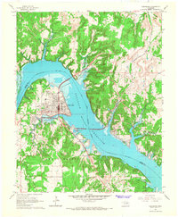 1966 Cleveland1967 Print · USGSCleveland and the Arkansas River valley are seen here in the mid-sixties as the newly formed reservoir reshaped the Pawnee County landscape. Researchers can locate family sites at Woodland Cemetery and Dixie Cem, or trace the rail corridor of the Missouri Kansas Texas.2 unique versions available
 - 1966 Map of New Prue, 1967 Print
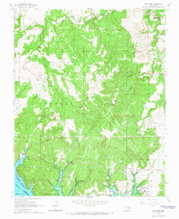 1966 New Prue1967 Print · USGSOsage County was undergoing a major geographic shift in the mid-sixties as the newly formed Keystone Reservoir altered the valley floor. Genealogists and historians can trace the early layout of New Prue and find industrial footprints in the Osage City Oil Field or near Wildhorse.3 unique versions available
 - 1968 Map of Ponca City SE, 1969 Print
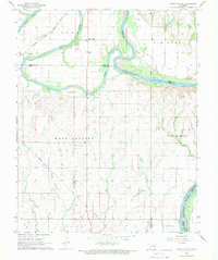 1968 Ponca City SE1969 Print · USGSThe confluence of the Salt Fork and Arkansas rivers defines this part of Noble County in the late sixties. Researchers can trace the Atchison Topeka and Santa Fe rail line and locate old community hubs like White Eagle and West Bressie.
End of results
Showing maps 1-3 of 3
Top cities of Pawnee County
- Cleveland historical maps
- Pawnee historical maps
- Jennings historical maps
- Ralston historical maps
- Westport historical maps
- Hallett historical maps
See more
Frequently asked questions
- What are the different types of historical maps available for Pawnee County?
- What is the oldest map of Pawnee County?
- Where can I purchase historical maps of Pawnee County for my home or office?
- Where can I download high-res historical maps of Pawnee County?
- Are there historical topographic maps available for Pawnee County?
- Is there historical aerial imagery available for Pawnee County?
- Where are historical maps of Pawnee County sourced from?