1930s Maps of Pawnee County, Oklahoma
Explore 7 historic maps of Pawnee County from the 1930s. These maps offer a rare glimpse into what life looked like during the 1930s — showing old roads, neighborhoods, homes, and landmarks that have changed or disappeared over time.
Whether you're researching your family's past, planning a metal detecting trip, or studying how Pawnee County's landscape evolved across the 1930s, these high-resolution maps are a powerful tool for exploring the history of this region.
- Focus on a specific era: All maps on this page are from the 1930s, giving you a focused view of this time period.
- See what’s changed: Compare century-old streets, trails, and buildings to today's modern landscape using overlays and satellite layers.
- Research with precision: Use these maps for genealogy, historical research, land use analysis, or educational projects.
- View, download, or print: Maps are fully viewable online in high resolution, and can be downloaded or printed for your own records.
Start exploring Pawnee County's history through authentic maps from the 1930s. This is your window into the past.
Pawnee County, OK maps
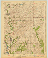
(7)- 1930 Map of Pawnee, 1958 Print
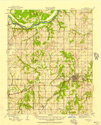 1930 Pawnee1958 Print · USGSNorth-central Oklahoma at the start of the 1930s shows a landscape shaped by river commerce, the oil industry, and early rail lines. Local historians can trace the Pawnee Indian School Reservation, the Old Town Trading Post, and numerous rural school sites like Highland Sch.
 - 1931 Map of Skedee
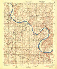 1931 Skedee1931 Print · USGSPawnee and Osage counties are shown here during the late 1920s, when river crossings and rural schools defined the community landscape. Genealogists can locate family landmarks like the Bug Creek Indian Camp, Mt Pleasant Cemetery, and the East Bend Ferry.3 unique versions available
 - 1932 Map of Yale
 1932 Yale1932 Print · USGSThe oil-rich landscape along the Cimarron River is captured here just after the peak of the regional boom. Researchers can locate early schools and burial sites like Pleasantvale Sch and Greenwood Cem, alongside major petroleum infrastructure like the 35 Oil Tanks near Oilton.3 unique versions available
 - 1932 Map of Ripley
 1932 Ripley1932 Print · USGSRipley and Glencoe anchor this Depression-era portrait of the Oklahoma landscape as the oil industry began to mark the riverbanks. Researchers can locate dozens of vanished rural schools and early landmarks like Twin Mounds, the Payne County Farm, and the Signet PO.2 unique versions available
 - 1932 Map of Fairfax
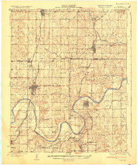
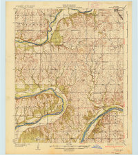
 1932 Fairfax1932 Print · USGSOsage County is shown at the height of its oil-era development in the early thirties. Local historians can trace the industrial footprint of Carter Nine, find rural landmarks like St Johns Sch, and follow the Atchison Topeka and Santa Fe rail line.4 unique versions available
 - 1936 Map of Belford
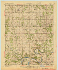
 1936 Belford1936 Print · USGSOsage and Noble counties come into focus in the mid-1930s, showing a rural landscape defined by the winding Arkansas River. Genealogists and local historians can trace numerous country school sites like Braden Sch and Pleasant Valley Sch, alongside the Atchison Topeka and Santa Fe Ry through Apperson.3 unique versions available
 - 1936 Map of Pawnee
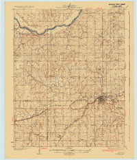 1936 Pawnee1936 Print · USGSPawnee County and the surrounding cattle and oil country come alive in this mid-thirties survey of the Oklahoma plains. Researchers can locate dozens of country schools like Star A Star Sch and trace the Pawnee Indian School Reservation and the Old Town Trading Post.2 unique versions available
End of results
Showing maps 1-7 of 7
Top cities of Pawnee County
- Cleveland historical maps
- Pawnee historical maps
- Jennings historical maps
- Ralston historical maps
- Westport historical maps
- Hallett historical maps
See more
Frequently asked questions
- What are the different types of historical maps available for Pawnee County?
- What is the oldest map of Pawnee County?
- Where can I purchase historical maps of Pawnee County for my home or office?
- Where can I download high-res historical maps of Pawnee County?
- Are there historical topographic maps available for Pawnee County?
- Is there historical aerial imagery available for Pawnee County?
- Where are historical maps of Pawnee County sourced from?