1970s Maps of Roger Mills County, Oklahoma
Explore 3 historic maps of Roger Mills County from the 1970s. These maps offer a rare glimpse into what life looked like during the 1970s — showing old roads, neighborhoods, homes, and landmarks that have changed or disappeared over time.
Whether you're researching your family's past, planning a metal detecting trip, or studying how Roger Mills County's landscape evolved across the 1970s, these high-resolution maps are a powerful tool for exploring the history of this region.
- Focus on a specific era: All maps on this page are from the 1970s, giving you a focused view of this time period.
- See what’s changed: Compare century-old streets, trails, and buildings to today's modern landscape using overlays and satellite layers.
- Research with precision: Use these maps for genealogy, historical research, land use analysis, or educational projects.
- View, download, or print: Maps are fully viewable online in high resolution, and can be downloaded or printed for your own records.
Start exploring Roger Mills County's history through authentic maps from the 1970s. This is your window into the past.
Roger Mills County, OK maps
(3)- 1970 Map of Arnett SE, 1972 Print
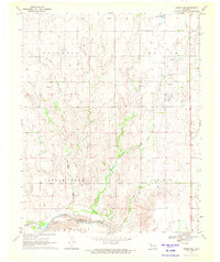 1970 Arnett SE1972 Print · USGSThe rural borders of Ellis and Roger Mills counties are documented here in 1970, centered on the Canadian River valley. Researchers can locate the Grand Cem and trace the paths of Mosquito Creek and Commission Creek.
 - 1970 Map of Vici SW, 1972 Print
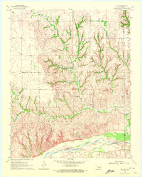 1970 Vici SW1972 Print · USGSThe borderlands of Ellis and Roger Mills counties are shown in the early 1970s as the high plains descend toward the river. Local researchers can trace family landmarks like Stone Cem and the Cree Ranch near the Canadian River.
 - 1972 Map of Dreyfoos, 1974 Print
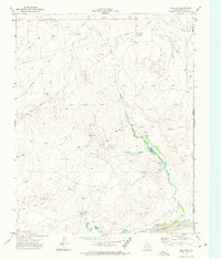 1972 Dreyfoos1974 Print · USGSHemphill County and the Oklahoma border are captured here in the early 1970s during a period of active oil exploration and ranching. Researchers can trace the network of oil wells around Dreyfoos or locate landmarks like Goettsche Lake and the McQuiddy Curves.
End of results
Showing maps 1-3 of 3
Top cities of Roger Mills County
Frequently asked questions
- What are the different types of historical maps available for Roger Mills County?
- What is the oldest map of Roger Mills County?
- Where can I purchase historical maps of Roger Mills County for my home or office?
- Where can I download high-res historical maps of Roger Mills County?
- Are there historical topographic maps available for Roger Mills County?
- Is there historical aerial imagery available for Roger Mills County?
- Where are historical maps of Roger Mills County sourced from?