
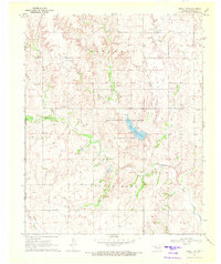
1970 Map of Arnett SE
USGS Topo · Published 1972About this map
The Canadian River winds through the southern reaches of this landscape, marking the natural boundary between Ellis and Roger Mills counties. This 1970 snapshot of western Oklahoma shows a terrain defined by its complex drainage systems, where the perennial flow of the river is fed by numerous tributaries including West Red Bluff Creek, Mosquito Creek, and Commission Creek. The rugged breaks near the river contrast with the upland prairie where small-scale industrial activity is evident through scattered Gravel Pits and a Sandpit in the eastern section.
Find a feature on this map
16 named features on this map. Tap any name to fly to it.
Don’t see what you’re looking for? This feature index may not catch every label — zoom into the map to look around manually.
Map Details
Editions of this 1970 Arnett SE Map
This is the sole edition of this map. No revisions or reprints were ever made.
Other maps of this area

1955 · Clinton
USGS Topo · 1:250,000

1955 · Woodward
USGS Topo · 1:250,000

1957 · Clinton
USGS Topo · 1:250,000

1958 · Woodward
USGS Topo · 1:250,000

1965 · Roll NW
USGS Topo · 1:24,000

1966 · Antelope Hills NE
USGS Topo · 1:24,000

1966 · Antelope Hills
USGS Topo · 1:24,000

1970 · Arnett
USGS Topo · 1:24,000

1970 · Harmon SW
USGS Topo · 1:24,000
1970 · Arnett SW
USGS Topo · 1:24,000