1970s Maps of Seminole County, Oklahoma
Explore 8 historic maps of Seminole County from the 1970s. These maps offer a rare glimpse into what life looked like during the 1970s — showing old roads, neighborhoods, homes, and landmarks that have changed or disappeared over time.
Whether you're researching your family's past, planning a metal detecting trip, or studying how Seminole County's landscape evolved across the 1970s, these high-resolution maps are a powerful tool for exploring the history of this region.
- Focus on a specific era: All maps on this page are from the 1970s, giving you a focused view of this time period.
- See what’s changed: Compare century-old streets, trails, and buildings to today's modern landscape using overlays and satellite layers.
- Research with precision: Use these maps for genealogy, historical research, land use analysis, or educational projects.
- View, download, or print: Maps are fully viewable online in high resolution, and can be downloaded or printed for your own records.
Start exploring Seminole County's history through authentic maps from the 1970s. This is your window into the past.
Seminole County, OK maps
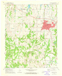
(8)- 1972 Map of Seminole, 1974 Print
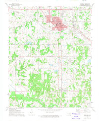 1972 Seminole1974 Print · USGSSeminole and the surrounding oil fields are captured here in the early seventies during a period of established industrial activity. Researchers can trace the path of the Chicago Rock Island and Pacific railroad or locate family burial sites at Maple Grove Cem, Kinnelworth Cem, and Mekusukey Ch.3 unique versions available
 - 1972 Map of Maud, 1974 Print
 1972 Maud1974 Print · USGSThe Oklahoma oil patch near Maud is captured here in the early seventies as the petroleum and rail economy shaped the border between Pottawatomie and Seminole counties. Researchers can trace the Old Indian Treaty Boundary and locate family burial sites at Union Cems and Fairview Cem.
 - 1972 Map of Wewoka West, 1974 Print
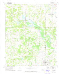
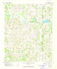
 1972 Wewoka West1974 Print · USGSSeminole County was a landscape of industry and community in the early seventies, dominated by petroleum extraction and rail transport. Genealogists and local historians can trace family-named sites and vanished landmarks like Nobletown, King Chapel, and the Westwood Cem.
 - 1972 Map of Wewoka East, 1974 Print
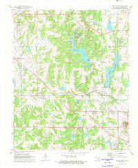
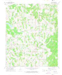
 1972 Wewoka East1974 Print · USGSOklahoma's oil-rich countryside comes into focus during the early seventies, centered on the growing county seat and its rail connections. Researchers can trace the layout of Wewoka, find rural landmarks like Pilgrims Rest Ch, or locate family sites near Oakwood Cem.
 - 1972 Map of St. Louis, 1974 Print
 1972 St. Louis1974 Print · USGSCentral Oklahoma's petroleum landscape is captured here in the early seventies, spanning the border of Pottawatomie and Seminole counties. Trace the extensive St Louis Oil Field and find historic sites like Sacred Heart and Collins Cem.2 unique versions available
 - 1972 Map of Wolf, 1974 Print
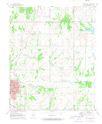
 1972 Wolf1974 Print · USGSSeminole County in the early seventies was a landscape defined by petroleum production and rural community life. Researchers can trace family history through sites like Wolf Cem and Harjo Cem or locate the sprawling Oil Field and the Atchison Topeka and Santa Fe railroad.2 unique versions available
 - 1972 Map of Holdenville, 1974 Print
 1972 Holdenville1974 Print · USGSHoldenville and the surrounding Oklahoma oil fields are captured in detail during the early seventies. Genealogists and historians can trace family sites at Buchner Memorial Cemetery, local schools like Thomas School, and industrial landmarks across the Jacobs Oil Field.
 - 1972 Map of Tate Mountain, 1974 Print
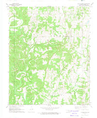 1972 Tate Mountain1974 Print · USGSThe rural landscape of Seminole County in the early seventies shows a territory busy with oil exploration and community life. Researchers can trace family roots at Tate Mountain Cem or locate old school sites like Justice Sch and New Model Sch.2 unique versions available
End of results
Showing maps 1-8 of 8
Top cities of Seminole County
- Seminole historical maps
- Wewoka historical maps
- Konawa historical maps
- Bowlegs historical maps
- Cromwell historical maps
- Sasakwa historical maps
See more
Frequently asked questions
- What are the different types of historical maps available for Seminole County?
- What is the oldest map of Seminole County?
- Where can I purchase historical maps of Seminole County for my home or office?
- Where can I download high-res historical maps of Seminole County?
- Are there historical topographic maps available for Seminole County?
- Is there historical aerial imagery available for Seminole County?
- Where are historical maps of Seminole County sourced from?