1900-1909 Maps of Seminole County, Oklahoma
Explore 6 historic maps of Seminole County from 1900-1909. These maps offer a rare glimpse into what life looked like during the 1900s — showing old roads, neighborhoods, homes, and landmarks that have changed or disappeared over time.
Whether you're researching your family's past, planning a metal detecting trip, or studying how Seminole County's landscape evolved across the 1900s, these high-resolution maps are a powerful tool for exploring the history of this region.
- Focus on a specific era: All maps on this page are from the 1900s, giving you a focused view of this time period.
- See what’s changed: Compare century-old streets, trails, and buildings to today's modern landscape using overlays and satellite layers.
- Research with precision: Use these maps for genealogy, historical research, land use analysis, or educational projects.
- View, download, or print: Maps are fully viewable online in high resolution, and can be downloaded or printed for your own records.
Start exploring Seminole County's history through authentic maps from the 1900s. This is your window into the past.
Seminole County, OK maps
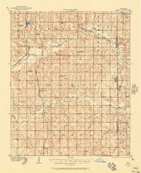
(6)- 1900 Map of Wewoka
 1900 Wewoka1900 Print · USGSIndian Territory at the turn of the century shows a landscape defined by tribal nations and the early expansion of the railway. Genealogists can trace family homesteads near Wewoka and Holdenville, or locate remote landmarks like Marks Store and the Baptist Mission.4 unique versions available
 - 1900 Map of Coalgate
 1900 Coalgate1900 Print · USGSIndian Territory at the turn of the century shows a land of tribal boundaries and emerging coal towns. Researchers can trace the early rail corridors of the M. K. and T. R. R. and locate vanished communities like Guertie, Citra, and Legal.3 unique versions available
 - 1901 Map of Stonewall
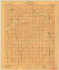
 1901 Stonewall1901 Print · USGSBefore Oklahoma statehood, this late-century survey captures the Chickasaw Nation and Seminole Nation borderlands in high detail. Researchers can locate early schools like Collins Institute and trace the paths between settlements such as Stonewall, Ada, and Fitzhugh.4 unique versions available
 - 1907 Map of Maud, 1957 Print
 1907 Maud1957 Print · USGSPottawatomie County at the dawn of statehood shows a landscape of emerging rail towns and scattered country schoolhouses. Researchers can trace the early footprints of Maud and Pearson or locate family landmarks like Sacred Heart P O Georgetown and New Paradise School.
 - 1908 Map of Maud
 1908 Maud1908 Print · USGSCentral Oklahoma at the time of statehood shows a landscape of emerging rail towns and rural school districts. Genealogists can trace family roots through sites like Sacred Heart P.O. and Maud, or find vanished schoolhouses such as New Paradise School and Antioch Schools.3 unique versions available
 - 1909 Map of Shawnee
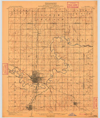 1909 Shawnee1909 Print · USGSPottawatomie County thrives as a booming rail and agricultural center in the first years of Oklahoma statehood. Genealogists can trace the early grids of Shawnee and Tecumseh or find rural landmarks like Shawnee Mission and Econtuchka.3 unique versions available
End of results
Showing maps 1-6 of 6
Top cities of Seminole County
- Seminole historical maps
- Wewoka historical maps
- Konawa historical maps
- Bowlegs historical maps
- Cromwell historical maps
- Sasakwa historical maps
See more
Frequently asked questions
- What are the different types of historical maps available for Seminole County?
- What is the oldest map of Seminole County?
- Where can I purchase historical maps of Seminole County for my home or office?
- Where can I download high-res historical maps of Seminole County?
- Are there historical topographic maps available for Seminole County?
- Is there historical aerial imagery available for Seminole County?
- Where are historical maps of Seminole County sourced from?