1980s Maps of Hope, Bray
Explore 2 historic maps of Hope from the 1980s. These maps offer a rare glimpse into what life looked like during the 1980s — showing old roads, neighborhoods, homes, and landmarks that have changed or disappeared over time.
Whether you're researching your family's past, planning a metal detecting trip, or studying how Hope's landscape evolved across the 1980s, these high-resolution maps are a powerful tool for exploring the history of this region.
- Focus on a specific era: All maps on this page are from the 1980s, giving you a focused view of this time period.
- See what’s changed: Compare century-old streets, trails, and buildings to today's modern landscape using overlays and satellite layers.
- Research with precision: Use these maps for genealogy, historical research, land use analysis, or educational projects.
- View, download, or print: Maps are fully viewable online in high resolution, and can be downloaded or printed for your own records.
Start exploring Hope's history through authentic maps from the 1980s. This is your window into the past.
Hope, Bray maps
(2)- 1982 Map of Hope
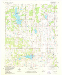 1982 Hope1982 Print · USGSStephens County in the early eighties shows a landscape of growing reservoirs and active oil production near the town of Bray. Genealogists and local historians can locate Cooper Cem, trace the waters of Wildhorse Creek, or find Camp Waluhiyi.
 - 1986 Map of Pauls Valley
 1986 Pauls Valley1986 Print · USGSGarvin County and its neighbors are shown in the mid-1980s during a period of steady growth along the Washita River. Researchers can trace the path of the Atchison Topeka and Santa Fe railroad through Pauls Valley or locate rural sites like Mt Olive Church and Erin Springs.2 unique versions available
End of results
Showing maps 1-2 of 2
Top cities near Hope
- Duncan historical maps
- Marlow historical maps
- Comanche historical maps
- Rush Springs historical maps
- Bray historical maps
- Central High historical maps
See more
Frequently asked questions
- What are the different types of historical maps available for Hope?
- What is the oldest map of Hope?
- Where can I purchase historical maps of Hope for my home or office?
- Where can I download high-res historical maps of Hope?
- Are there historical topographic maps available for Hope?
- Is there historical aerial imagery available for Hope?
- Where are historical maps of Hope sourced from?