1970s Maps of Bartlesville, Oklahoma
Explore 5 historic maps of Bartlesville from the 1970s. These maps offer a rare glimpse into what life looked like during the 1970s — showing old roads, neighborhoods, homes, and landmarks that have changed or disappeared over time.
Whether you're researching your family's past, planning a metal detecting trip, or studying how Bartlesville's landscape evolved across the 1970s, these high-resolution maps are a powerful tool for exploring the history of this region.
- Focus on a specific era: All maps on this page are from the 1970s, giving you a focused view of this time period.
- See what’s changed: Compare century-old streets, trails, and buildings to today's modern landscape using overlays and satellite layers.
- Research with precision: Use these maps for genealogy, historical research, land use analysis, or educational projects.
- View, download, or print: Maps are fully viewable online in high resolution, and can be downloaded or printed for your own records.
Start exploring Bartlesville's history through authentic maps from the 1970s. This is your window into the past.
Bartlesville, OK maps
(5)- 1971 Map of Bartlesville South, 1973 Print
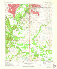 1971 Bartlesville South1973 Print · USGSBartlesville was a thriving education and energy hub in the early seventies, caught here as residential life expanded south toward the river. Genealogists and historians can trace institutional sites like Wesleyan College and Memorial Park Cemetery or follow the rails of the Missouri Kansas and Texas.3 unique versions available
 - 1971 Map of Woolaroc, 1973 Print
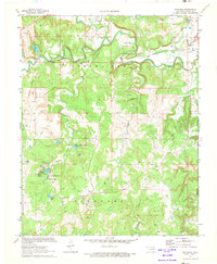 1971 Woolaroc1973 Print · USGSOsage County in the early seventies shows a landscape where high-culture estates and heavy industry meet. Genealogists and historians can locate the Woolaroc Museum, trace the Missouri-Kansas-Texas rail line, and find local landmarks like Osage Hills Sch.2 unique versions available
 - 1971 Map of Bartlesville North, 1973 Print
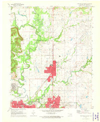 1971 Bartlesville North1973 Print · USGSNorthern Oklahoma's petroleum and rail corridors are captured in the early seventies, centered on the growing towns of Dewey and Bartlesville. Researchers can trace the extensive Jefferson Oil Field operations or locate local landmarks like the Antioch Ch and Johnstone Park.2 unique versions available
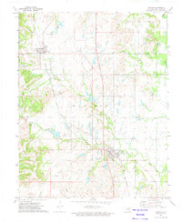
 - 1971 Map of Bowring SE, 1973 Print
 1971 Bowring SE1973 Print · USGSOsage and Washington counties in the early 1970s showcase a transition between petroleum production and growing recreational development. Genealogists and historians can trace the industrial footprint of Caney Field and local social life at the Sunset Country Club.
 - 1972 Map of Ramona, 1974 Print
 1972 Ramona1974 Print · USGSNortheastern Oklahoma's oil and rail landscape is captured here in the early seventies, centered on the towns of Ochelata and Ramona. Genealogists and historians can trace family sites at Happy Hill Ch or the Ramona Cem while mapping the era's energy boom via dozens of Oil Wells.2 unique versions available
End of results
Showing maps 1-5 of 5
Top cities near Bartlesville
- Dewey historical maps
- Barnsdall historical maps
- Copan historical maps
- Ramona historical maps
- Ochelata historical maps
- Avant historical maps
See more
Top neighborhoods of Bartlesville
Frequently asked questions
- What are the different types of historical maps available for Bartlesville?
- What is the oldest map of Bartlesville?
- Where can I purchase historical maps of Bartlesville for my home or office?
- Where can I download high-res historical maps of Bartlesville?
- Are there historical topographic maps available for Bartlesville?
- Is there historical aerial imagery available for Bartlesville?
- Where are historical maps of Bartlesville sourced from?