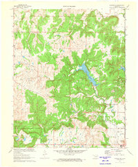
1971 Map of Bowring SE
USGS Topo · Published 1973About this map
The Oklahoma landscape of Osage Co and Washington Co in the early 1970s is defined by a dual economy of resource extraction and mid-century recreation. Significant water infrastructure centers on Lake Hudson and the smaller Bar-Dew Lake, with the Waterworks Intake and a long Aqueduct highlighting the region's managed water supply. Petroleum industry activity is evident through the numerous Oil Wells, Drill Holes, and a crossing Pipeline, particularly within the Caney Field area. Transportation and social hubs appear at the Frank Phillips Airport and the nearby Sunset Country Club. Natural drainage patterns are shaped by several major waterways, including Mission Creek, Butler Creek, and Buck Creek, while landmarks like The Mound and Strike Axe provide distinct geographical reference points in this varied terrain.
Find a feature on this map
23 named features on this map. Tap any name to fly to it.
Don’t see what you’re looking for? This feature index may not catch every label — zoom into the map to look around manually.
Map Details
Editions of this 1971 Bowring SE Map
This is the sole edition of this map. No revisions or reprints were ever made.
Other maps of this area

1901 · Nowata
USGS Topo · 1:125,000

1906 · Nelagoney
USGS Topo · 1:24,000

1909 · Pawhuska
USGS Topo · 1:125,000

1910 · Pawhuska
USGS Topo · 1:125,000

1914 · Nowata
USGS Topo · 1:125,000

1954 · Tulsa
USGS Topo · 1:250,000

1955 · Enid
USGS Topo · 1:250,000

1958 · Enid
USGS Topo · 1:250,000

1958 · Tulsa
USGS Topo · 1:250,000

1960 · Nelagoney
USGS Topo · 1:24,000