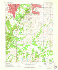
1971 Map of Bartlesville South
USGS Topo · Published 1973About this map
The Caney River winds through the heart of this early 1970s landscape, illustrating the suburban expansion and industrial footprint of south Bartlesville. This era shows a dense educational infrastructure, from specialized institutions like Wesleyan College and Tri-County Technical Sch to numerous neighborhood campuses such as College High Sch and Sooner High Sch. The town's civic importance is anchored by the Courthouse, while the outskirts are defined by an extensive Oil Field and numerous Gas Wells, highlighting the region's energy-driven economy. Transportation is dominated by the intersecting tracks of the Atchison Topeka and Santa Fe and the Missouri Kansas and Texas railroads, which share the landscape with modern features like a Drive-in Theater and the growing residential blocks of Jackson Township.
Find a feature on this map
48 named features on this map. Tap any name to fly to it.
Don’t see what you’re looking for? This feature index may not catch every label — zoom into the map to look around manually.
Map Details
Editions of this 1971 Bartlesville South Map
3 editions found
Other maps of this area

1901 · Nowata
USGS Topo · 1:125,000

1909 · Pawhuska
USGS Topo · 1:125,000

1910 · Pawhuska
USGS Topo · 1:125,000

1914 · Nowata
USGS Topo · 1:125,000

1954 · Tulsa
USGS Topo · 1:250,000

1955 · Enid
USGS Topo · 1:250,000

1958 · Enid
USGS Topo · 1:250,000

1958 · Tulsa
USGS Topo · 1:250,000

1963 · Tulsa
USGS Topo · 1:250,000

1970 · Bartlesville SE
USGS Topo · 1:24,000