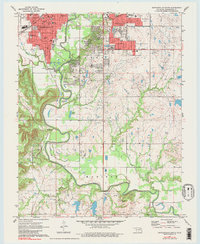
1971 Map of Bartlesville South
USGS Topo · Published 1983About this map
Bartlesville serves as the focal point of this Oklahoma landscape, where the urban grid meets the meandering path of the Caney River. The map details a robust educational and civic infrastructure, from the Courthouse downtown to a network of local schools including Wesleyan College, College High Sch, and Tri-County Technical Sch. The southern reaches transition into the floodplain, where Silver Lake and the small settlement of Matoaka sit along the winding riverbanks. Industrial and transit lines are prominently marked, with the Missouri Pacific and Atchison Topeka and Santa Fe railroads cutting through the terrain. Evidence of the region's resource economy is visible in the scattered Gas Wells and Quarries that dot the countryside, while local history is preserved at White Rose Cem and Memorial Park Cemetery.
Find a feature on this map
54 named features on this map. Tap any name to fly to it.
Don’t see what you’re looking for? This feature index may not catch every label — zoom into the map to look around manually.
Map Details
Editions of this 1971 Bartlesville South Map
3 editions found
Other maps of this area

1901 · Nowata
USGS Topo · 1:125,000

1909 · Pawhuska
USGS Topo · 1:125,000

1910 · Pawhuska
USGS Topo · 1:125,000

1914 · Nowata
USGS Topo · 1:125,000

1954 · Tulsa
USGS Topo · 1:250,000

1955 · Enid
USGS Topo · 1:250,000

1958 · Enid
USGS Topo · 1:250,000

1958 · Tulsa
USGS Topo · 1:250,000

1963 · Tulsa
USGS Topo · 1:250,000

1970 · Bartlesville SE
USGS Topo · 1:24,000