
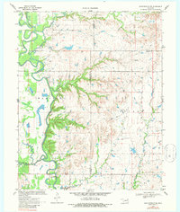
1970 Map of Bartlesville SE
USGS Topo · Published 1972About this map
Caney River winds through this landscape at the junction of Washington, Nowata, and Rogers counties, carving a wide valley defined by intricate oxbows and seasonal floodplains. The hydrology of the region is highly documented, featuring the Tyner Dam and a Gaging Station used to monitor the flow of the many tributaries like Hogshooter Creek and Double Creek. The map reflects an era of active resource extraction and water management in the Madison and Talala districts. Local industry is anchored by a Gravel Pit and scattered petroleum infrastructure, including a noted Oil Well near the riverbanks. This 1970s survey captures the rural character of the Oklahoma prairie before modern land-use shifts, preserving the precise locations of small-scale dams and creek systems such as Stick Creek and Rabb Creek.
Find a feature on this map
19 named features on this map. Tap any name to fly to it.
Don’t see what you’re looking for? This feature index may not catch every label — zoom into the map to look around manually.
Map Details
Editions of this 1970 Bartlesville SE Map
2 editions found
Other maps of this area

1901 · Claremore
USGS Topo · 1:125,000

1901 · Nowata
USGS Topo · 1:125,000

1914 · Nowata
USGS Topo · 1:125,000

1914 · Claremore
USGS Topo · 1:125,000

1916 · Claremore
USGS Topo · 1:125,000

1954 · Tulsa
USGS Topo · 1:250,000

1958 · Tulsa
USGS Topo · 1:250,000

1959 · Collinsville NE
USGS Topo · 1:24,000
1959 · Vera
USGS Topo · 1:24,000

1963 · Tulsa
USGS Topo · 1:250,000