Old Maps of Woodward County, Oklahoma for Academic Research
Study the evolution of Woodward County with 193 high-resolution historic maps. Whether you're teaching, researching, or modeling changes in land use, these maps provide essential visual documentation of urban, environmental, and geographic change.
- Analyze long-term change: Track patterns in development, transportation, and natural features.
- Ideal for environmental or urban studies: Support academic projects with primary historical map data.
- Use in the classroom or lab: Educators and researchers rely on these maps to bring historical context to life.
These maps are a powerful tool for teaching, research, and visualizing how Woodward County has changed over the decades.
Woodward County, OK maps
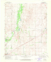
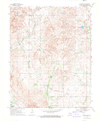
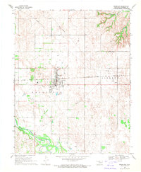
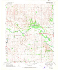
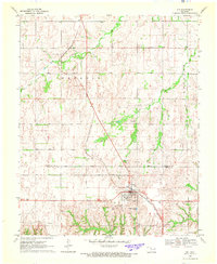
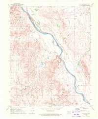
(193)- 1955 Map of Woodward, 1967 Print
 1955 Woodward1967 Print · USGSNorthwest Oklahoma and the bordering plains are captured during the mid-sixties, showing a landscape defined by river valleys and massive water projects. Researchers can trace family roots in towns like Woodward and Alva or locate landmarks such as the Western Oklahoma State Hospital and Kegelman AF.3 unique versions available
 - 1958 Map of Woodward
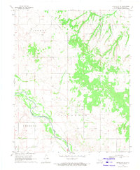
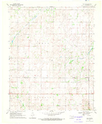
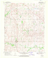
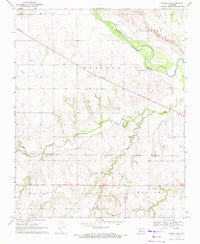
 1958 Woodward1958 Print · USGSNorthwest Oklahoma and the neighboring panhandle borders are shown here during a period of steady mid-century growth. Researchers can trace the rail networks of the Atchison Topeka and Santa Fe and locate landmarks like the Western Oklahoma State Hospital and Port Supply Reservoir.2 unique versions available
 - 1969 Map of Fargo, 1971 Print
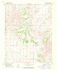
 1969 Fargo1971 Print · USGSWestern Oklahoma’s prairie landscape is captured here in the late sixties, centered on the Atchison Topeka and Santa Fe rail line. Genealogists and researchers can trace the early layouts of Fargo and Tangier, as well as landmarks like Rest Haven Cem and Braunch Memorial Park.
 - 1969 Map of Mooreland SE, 1971 Print
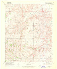
 1969 Mooreland SE1971 Print · USGSNorthwest Oklahoma's river valleys and energy fields are captured here in the late sixties as the region's economy balanced farming with oil and gas extraction. Researchers can locate the Miller Cem or trace industrial sites like the Landing Strip and the banks of the North Canadian River.
 - 1969 Map of Belva, 1971 Print
 1969 Belva1971 Print · USGSMajor County in the late sixties shows a landscape in transition from ranching to an energy-producing economy. Genealogists and researchers can trace the Atchison Topeka and Santa Fe Railroad Grade or locate landmarks like Belva and Bat Cave.
 - 1969 Map of Quinlan, 1971 Print
 1969 Quinlan1971 Print · USGSQuinlan and the surrounding Woodward County plains are captured here in the late sixties, centered on the Atchison Topeka and Santa Fe rail line. Researchers can locate family landmarks like Red Top Cem and Union Cem or trace the early development of local Gas Wells.2 unique versions available
 - 1969 Map of Waynoka NW, 1971 Print
 1969 Waynoka NW1971 Print · USGSWoods County in the late sixties reveals a landscape shaped by creek systems and the energy industry. Researchers can trace the Atchison Topeka and Santa Fe rail line past Morning Star Ch and the Sand Dunes of the river valley.
 - 1969 Map of Vici NW, 1971 Print
 1969 Vici NW1971 Print · USGSWestern Oklahoma’s ranching and oil country is captured here during the late sixties, where county lines follow the Old Indian Treaty Boundary. Researchers can trace the courses of North Persimmon Creek and Turkey Creek alongside landmarks like local Landing Strips and a Caliche Pit.
 - 1969 Map of Woodward SW, 1971 Print
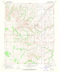
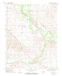
 1969 Woodward SW1971 Print · USGSWoodward County's rolling prairie landscape is captured in the late sixties as the region's energy infrastructure expanded across Jefferson and Woodward townships. Researchers can locate a rural Cem and trace the paths of Indian Creek and North Persimmon Creek alongside numerous Gas Wells.
 - 1969 Map of Woodward, 1971 Print
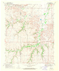
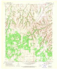
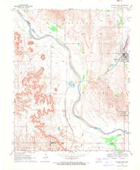
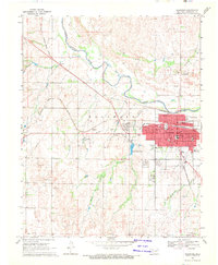 1969 Woodward1971 Print · USGSWoodward and the surrounding plains are captured in the late sixties as the city thrived as a rail and energy hub. Researchers can trace the intersection of the Atchison Topeka and Santa Fe railroad with local landmarks like Elmwood Cemetery and the Drive-in Theater.2 unique versions available
 - 1969 Map of Mooreland, 1971 Print
 1969 Mooreland1971 Print · USGSMooreland and the surrounding plains were a busy intersection of rail and river life in the late sixties. Researchers can trace family history at the Mooreland Cem, follow the Atchison Topeka and Santa Fe line, or locate the Powerplant.
 - 1969 Map of Sharon, 1971 Print
 1969 Sharon1971 Print · USGSNorthwestern Oklahoma’s prairie landscape is captured here in the late sixties as the town of Sharon remains tied to its rail and energy corridors. Genealogists and local historians can locate family burial sites at Vonton Cem and North Persimmon Cem or trace the route of the Missouri - Kansas - Texas railroad.
 - 1969 Map of Cedardale, 1971 Print
 1969 Cedardale1971 Print · USGSMajor and Woodward counties meet in this late 1960s survey of the Oklahoma plains during a period of active petroleum development. Genealogists and local historians can locate Cedardale Cem, Liberty Cem, and the small settlement of Cedardale.
 - 1969 Map of Fargo SE, 1971 Print
 1969 Fargo SE1971 Print · USGSThe border of Ellis and Woodward counties was a landscape of remote farmsteads and growing energy sites in the late sixties. Researchers can locate the early footprints of Fargo and Keenan, or trace rural family roots at Fargo Cem and Gnadenfield Cem.
 - 1969 Map of Woodward NE, 1971 Print
 1969 Woodward NE1971 Print · USGSThe Oklahoma plains north of Woodward are captured here during a period of industrial and recreational development in the late sixties. Researchers can trace the paths of the Atchison Topeka and Santa Fe rail line and identify local landmarks like Alston and Crystal Beach Lake.
 - 1969 Map of Waynoka West, 1971 Print
 1969 Waynoka West1971 Print · USGSWoods County in the late sixties reveals a landscape defined by the winding Cimarron River and the bustling rail operations in Waynoka. Genealogists and historians can trace the rail corridor through Heman or locate the early layout of the Little Sahara State Recreation Area.2 unique versions available
 - 1969 Map of Mooreland SW, 1971 Print
 1969 Mooreland SW1971 Print · USGSOklahoma's western prairie comes into focus in the late sixties as the river cuts through the plains of Woodward County. Genealogists and local historians can locate the North Chapel Cem, trace the Old Railroad Grade, or find the Community Hall near Moscow.
 - 1969 Map of Mutual, 1972 Print
 1969 Mutual1972 Print · USGSMutual and the surrounding Woodward and Dewey County borderlands are captured here in the late sixties, showing a landscape defined by ranching and the nascent energy industry. Researchers can trace the Old Indian Treaty Boundary and locate family sites like Persimmon Cem, Sunny Side Cem, or the Church of the First Born.
 - 1969 Map of Vici, 1972 Print
 1969 Vici1972 Print · USGSDewey and Woodward Counties are captured in the late sixties as the agricultural and rail life of the Oklahoma plains centered on the town of Vici. Genealogists and historians can trace family locations near Vassar Cem, South Persimmon Ch, and the historic Old Indian Treaty Boundary.
 - 1969 Map of Mutual NE, 1972 Print
 1969 Mutual NE1972 Print · USGSThe Woodward and Dewey County line area in the late sixties reveals a landscape shaped by early territories and river hydrology. Researchers can locate the Old Indian Treaty Boundary and trace family sites near Dunlap Cem and the settlement of Cestos.
 - 1970 Map of Fairvalley SW, 1972 Print
 1970 Fairvalley SW1972 Print · USGSWoodward County's energy and ranching landscape is captured in the early 1970s, as the industrial footprint expanded into rural Oklahoma. Trace the development of the Oil and Gas Field and its infrastructure, including a Pumping Station, Pipeline, and isolated Landing Strip.
 - 1970 Map of Harmon, 1972 Print
 1970 Harmon1972 Print · USGSNorthwestern Oklahoma in the early seventies reveals a landscape defined by ranching and the energy industry. Researchers can trace the Old Indian Treaty Boundary and locate local landmarks like the Harmon Cem and the Oil Refinery.2 unique versions available
 - 1970 Map of Alabaster Caverns, 1972 Print
 1970 Alabaster Caverns1972 Print · USGSWoodward County's gypsum-rich landscape is captured in the early seventies, centered on the unique subterranean systems of the region. Genealogists and explorers can locate Haskew Cem, the Community Center, and the surface layout of Alabaster Caverns State Park.
 - 1970 Map of Fairvalley SE, 1972 Print
 1970 Fairvalley SE1972 Print · USGSNorthwest Oklahoma's energy landscape is captured here just as the petroleum industry expanded across Woodward County. Researchers can locate family landmarks like Highland Cem and distinct natural features such as Chimney Rock and Doe Creek.
 - 1970 Map of Fairvalley, 1972 Print
 1970 Fairvalley1972 Print · USGSNorthwest Oklahoma's prairie landscape at the start of the seventies is defined by the winding Cimarron River and its rugged breaks. Genealogists and local historians can trace the rural communities of Fairvalley and Redhorse along the Atchison Topeka and Santa Fe railroad.
Showing maps 1-25 of 193
Top cities of Woodward County
- Woodward historical maps
- Mooreland historical maps
- Fort Supply historical maps
- Sharon historical maps
- Mutual historical maps
Frequently asked questions
- What are the different types of historical maps available for Woodward County?
- What is the oldest map of Woodward County?
- Where can I purchase historical maps of Woodward County for my home or office?
- Where can I download high-res historical maps of Woodward County?
- Are there historical topographic maps available for Woodward County?
- Is there historical aerial imagery available for Woodward County?
- Where are historical maps of Woodward County sourced from?