
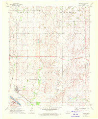
1969 Map of Waynoka NW
USGS Topo · Published 1971About this map
Whitehorse Creek and Eagle Chief Creek carve through this section of Woods County, defining a landscape of rolling terrain and drainage systems north of the Cimarron River. The late 1960s survey illustrates a rural economy transitioning through resource extraction, evidenced by numerous gas wells and a Sandpit scattered across the McKinley and Penn townships. The Atchison Topeka and Santa Fe railway cuts a diagonal path across the territory, serving as the primary transit corridor for the region. Social and environmental landmarks are sparse but significant, including the Morning Star Ch and McGill Lake. Near the southern border, prominent Sand Dunes edge the river valley, providing a distinct contrast to the creek-fed uplands to the north.
Find a feature on this map
11 named features on this map. Tap any name to fly to it.
Don’t see what you’re looking for? This feature index may not catch every label — zoom into the map to look around manually.
Map Details
Editions of this 1969 Waynoka NW Map
This is the sole edition of this map. No revisions or reprints were ever made.
Other maps of this area

1955 · Woodward
USGS Topo · 1:250,000

1958 · Woodward
USGS Topo · 1:250,000

1969 · Tegarden SE
USGS Topo · 1:24,000

1969 · Avard
USGS Topo · 1:24,000

1969 · Waynoka East
USGS Topo · 1:24,000

1969 · Tegarden
USGS Topo · 1:24,000

1969 · Waynoka West
USGS Topo · 1:24,000

1970 · Fairvalley SE
USGS Topo · 1:24,000

1970 · Fairvalley
USGS Topo · 1:24,000
1970 · Freedom
USGS Topo · 1:24,000