
1969 Map of Waynoka West
USGS Topo · Published 1971About this map
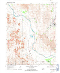
Waynoka serves as the primary hub in this late 1960s landscape, situated along the Atchison Topeka and Santa Fe railroad line. The Cimarron River carves a winding path across the terrain, joined by several tributaries including Sand Creek, Dog Creek, and West Creek. This era captures the region's balance between recreation and industry, with the Little Sahara State Recreation Area and its Picnic Area established near the river's edge, while numerous gas wells are scattered throughout the surrounding townships like McKinley and Union. Further south along the rail line, the smaller settlement of Heman provides a secondary point of reference for researchers tracking the movement of goods and people through Woods County. The map details the local infrastructure of the period, from the Gaging Station on Main Creek to the civic utility of the Sewage Disposal Pond near the town center.
Find a feature on this map
20 named features on this map. Tap any name to fly to it.
Don’t see what you’re looking for? This feature index may not catch every label — zoom into the map to look around manually.
Map Details
Editions of this 1969 Waynoka West Map
2 editions found
Other maps of this area

1955 · Woodward
USGS Topo · 1:250,000

1958 · Woodward
USGS Topo · 1:250,000

1969 · Belva
USGS Topo · 1:24,000

1969 · Quinlan
USGS Topo · 1:24,000

1969 · Waynoka NW
USGS Topo · 1:24,000

1969 · Avard
USGS Topo · 1:24,000

1969 · Waynoka East
USGS Topo · 1:24,000

1969 · Togo
USGS Topo · 1:24,000

1970 · Fairvalley SE
USGS Topo · 1:24,000

1970 · Fairvalley
USGS Topo · 1:24,000