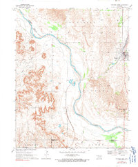
1969 Map of Waynoka West
USGS Topo · Published 1991About this map
The Cimarron River meanders across this Northwest Oklahoma landscape, shaping a environment of extensive Sand Dunes and shifting watercourses. In the late 1960s, the town of Waynoka sits at a critical junction of the Atchison Topeka and Santa Fe railroad, which dominates the local transportation network. To the south, the Little Sahara State Recreation Area preserves the distinctive dune topography that defines this section of the river valley. The map documents a sparsely settled region punctuated by industrial activity, evidenced by numerous Gas Wells scattered across the uplands. Near the railroad siding of Heman, the terrain transitions into the broken draws of Dog Creek and Sand Creek, while the Woods Co Woodward Co Boundary follows the center of the Cimarron, marking the jurisdictional divide in this river-driven economy.
Find a feature on this map
25 named features on this map. Tap any name to fly to it.
Don’t see what you’re looking for? This feature index may not catch every label — zoom into the map to look around manually.
Map Details
Editions of this 1969 Waynoka West Map
2 editions found
Other maps of this area

1955 · Woodward
USGS Topo · 1:250,000

1958 · Woodward
USGS Topo · 1:250,000

1969 · Belva
USGS Topo · 1:24,000

1969 · Quinlan
USGS Topo · 1:24,000

1969 · Waynoka NW
USGS Topo · 1:24,000

1969 · Avard
USGS Topo · 1:24,000

1969 · Waynoka East
USGS Topo · 1:24,000

1969 · Togo
USGS Topo · 1:24,000

1969 · Waynoka West
USGS Topo · 1:24,000

1970 · Fairvalley SE
USGS Topo · 1:24,000