1960s Maps of Benton County, Oregon
Explore 9 historic maps of Benton County from the 1960s. These maps offer a rare glimpse into what life looked like during the 1960s — showing old roads, neighborhoods, homes, and landmarks that have changed or disappeared over time.
Whether you're researching your family's past, planning a metal detecting trip, or studying how Benton County's landscape evolved across the 1960s, these high-resolution maps are a powerful tool for exploring the history of this region.
- Focus on a specific era: All maps on this page are from the 1960s, giving you a focused view of this time period.
- See what’s changed: Compare century-old streets, trails, and buildings to today's modern landscape using overlays and satellite layers.
- Research with precision: Use these maps for genealogy, historical research, land use analysis, or educational projects.
- View, download, or print: Maps are fully viewable online in high resolution, and can be downloaded or printed for your own records.
Start exploring Benton County's history through authentic maps from the 1960s. This is your window into the past.
Benton County, OR maps
(9)- 1960 Map of Salem, 1968 Print
 1960 Salem1968 Print · USGSThe Willamette Valley and the surrounding mountain ranges are shown here in the 1960s during a period of significant reservoir construction. Genealogists and historians can trace rail lines like the Oregon Electric and find communities from Lincoln City on the coast to Sweet Home and Mill City in the foothills.2 unique versions available
 - 1962 Map of Salem
 1962 Salem1962 Print · USGSThe Willamette Valley and the surrounding Oregon ranges are captured here in the early sixties, showing the vital growth of the state's primary agricultural and academic corridor. Researchers can trace the mid-century footprints of Oregon State University and the University of Oregon, alongside rural landmarks like Camp Adair and Black Butte Mine.
 - 1963 Map of Salem
 1963 Salem1963 Print · USGSMid-century Oregon comes into focus as the Willamette Valley’s timber and agricultural industries meet the growing campuses of Oregon State University and the University of Oregon. Researchers can trace old rail lines like the Oregon Electric Railway and locate family plots at Siletz Cem or Dallas Cem.
 - 1969 Map of Harrisburg, 1971 Print
 1969 Harrisburg1971 Print · USGSHarrisburg sits at a vital junction of the Willamette River and dual rail lines during the late sixties. Researchers can trace family roots through the Masonic Cem or locate rural landmarks like the Covered Bridge and the village of Lancaster.
 - 1969 Map of Riverside, 1971 Print
 1969 Riverside1971 Print · USGSThe Willamette River valley south of Albany comes into focus in the late sixties as a landscape of productive river-bottom farms and intersecting railroads. Researchers can trace family sites near the Oakville Cem, old country schools like Fairplay Sch, and the winding Muddy Creek.2 unique versions available
 - 1969 Map of Monroe, 1971 Print
 1969 Monroe1971 Print · USGSBenton and Lane counties are surveyed here in the late sixties, capturing the agricultural and timber corridor of the Willamette Valley. Genealogists can trace family names and sites such as Bellfountain Cem, Irish Bend Sch, and the settlement at Alpine.2 unique versions available
 - 1969 Map of Peoria, 1971 Print
 1969 Peoria1971 Print · USGSThe Willamette River valley in the late sixties reveals a network of shifting river bends and established farming communities. Researchers can trace family history through sites like Brattain Cem or follow the Oregon Electric rail line past Fayetteville and the Peoria riverfront.2 unique versions available
 - 1969 Map of Corvallis, 1973 Print
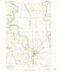
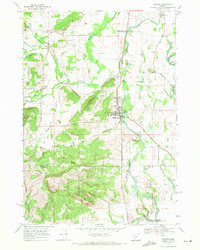
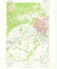 1969 Corvallis1973 Print · USGSBenton County in the late sixties reveals the collegiate and timber-driven character of the Willamette Valley. Genealogists and researchers can trace the limits of Philomath, find local landmarks like Mt Union Cem, and explore the sprawling grounds of Oregon State Univ.3 unique versions available
 - 1969 Map of Greenberry, 1973 Print
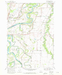
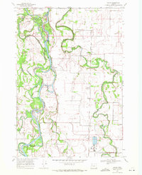
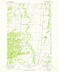 1969 Greenberry1973 Print · USGSBenton County was a landscape of fertile bottomlands and rising foothills in the late sixties, just as the regional wildlife refuge was being established. Genealogists and local historians can trace family locations near Oakridge Cem, the Inavale Sch, and the small rail stops of Shrock and Greenberry.3 unique versions available
End of results
Showing maps 1-9 of 9
Top cities of Benton County
- Corvallis historical maps
- Philomath historical maps
- Monroe historical maps
- Adair Village historical maps
Frequently asked questions
- What are the different types of historical maps available for Benton County?
- What is the oldest map of Benton County?
- Where can I purchase historical maps of Benton County for my home or office?
- Where can I download high-res historical maps of Benton County?
- Are there historical topographic maps available for Benton County?
- Is there historical aerial imagery available for Benton County?
- Where are historical maps of Benton County sourced from?