1980s Maps of Benton County, Oregon
Explore 14 historic maps of Benton County from the 1980s. These maps offer a rare glimpse into what life looked like during the 1980s — showing old roads, neighborhoods, homes, and landmarks that have changed or disappeared over time.
Whether you're researching your family's past, planning a metal detecting trip, or studying how Benton County's landscape evolved across the 1980s, these high-resolution maps are a powerful tool for exploring the history of this region.
- Focus on a specific era: All maps on this page are from the 1980s, giving you a focused view of this time period.
- See what’s changed: Compare century-old streets, trails, and buildings to today's modern landscape using overlays and satellite layers.
- Research with precision: Use these maps for genealogy, historical research, land use analysis, or educational projects.
- View, download, or print: Maps are fully viewable online in high resolution, and can be downloaded or printed for your own records.
Start exploring Benton County's history through authentic maps from the 1980s. This is your window into the past.
Benton County, OR maps
(14)- 1980 Map of Eugene
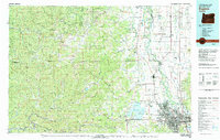 1980 Eugene1980 Print · USGSThe southern Willamette Valley and Coast Range are captured in the early eighties as the urban centers of Eugene and Springfield expanded. Researchers can trace the legacy of family estates and regional infrastructure through landmarks like Mahlon Sweet Airport, Fern Ridge Lake, and Junction City.
 - 1980 Map of Corvallis, 1981 Print
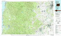 1980 Corvallis1981 Print · USGSThe Oregon Coast Range meets the fertile Willamette Valley in the early eighties, documenting a landscape of timber, agriculture, and growing college towns. Genealogists and historians can trace old rail lines like the Southern Pacific or locate landmarks like Marys Peak and the College of Education.
 - 1984 Map of Kings Valley
 1984 Kings Valley1984 Print · USGSKings Valley and the Luckiamute River corridor appear here in the early 1980s, balancing modern forestry with its pioneer roots. Researchers can trace historic family burial sites at Edwards Cem, locate the Fort Hoskins (Site), or find the local Covered Bridge.
 - 1984 Map of Flat Mountain
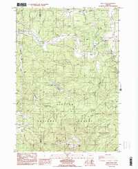
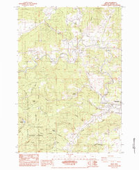
 1984 Flat Mountain1984 Print · USGSBenton County in the mid-1980s reveals a working landscape where the timberlands of the Siuslaw National Forest meet rural valley homesteads. Genealogists and hikers can trace the paths near Powell Cem or locate old landmarks like Flat Mountain and Bunker Hill.
 - 1984 Map of Marys Peak
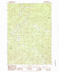
 1984 Marys Peak1984 Print · USGSBenton and Lincoln counties are captured here in the mid-1970s and early 1980s as the regional timber and rail economy flourished. Genealogists can trace family footprints at Mulkey Cem and Davidson Cem or locate the old Blodgett Sch near the Southern Pacific tracks.2 unique versions available
 - 1984 Map of Grass Mtn
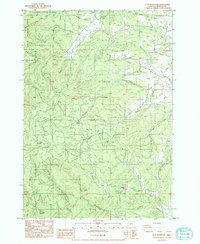
 1984 Grass Mtn1984 Print · USGSThe Oregon Coast Range in the mid-eighties shows a rugged landscape of timber management and river culture along the Lincoln and Benton County line. Researchers can locate the Covered Bridge on the Alsea River and the Fall Creek State Fish Hatchery.
 - 1984 Map of Summit
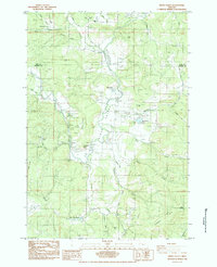
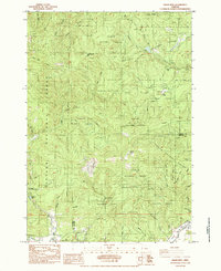
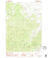
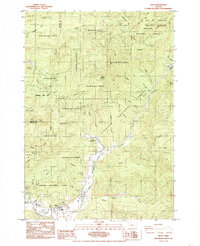
 1984 Summit1984 Print · USGSThe Coast Range summit of Benton County comes into focus in the mid-1980s, where the headwaters of the Luckiamute and Marys rivers meet. Genealogists and local historians can trace family plots at Claremont Cem and May Stouts Cem or follow the Southern Pacific rail line through Summit.
 - 1984 Map of Digger Mtn
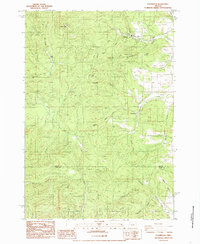
 1984 Digger Mtn1984 Print · USGSThe Alsea River valley in the early 1980s reveals a landscape of remote timberlands and river-based recreation at the Benton-Lincoln county line. Trace local landmarks like the Missouri Bend School, the Lone Fir Cem, and the winding Lobster Creek.
 - 1984 Map of Wren
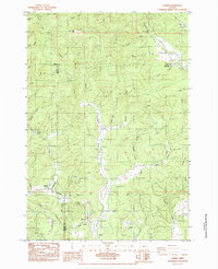
 1984 Wren1984 Print · USGSBenton County timberlands and river valleys are captured here in the mid-eighties, showcasing the rural landscapes near Wren and Philomath. Researchers can locate the Pleasant Valley Cem, a Covered Bridge, and old Southern Pacific rail lines.
 - 1984 Map of Airlie South
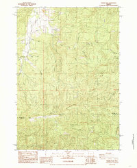
 1984 Airlie South1984 Print · USGSThe Coast Range foothills of Benton County appear in the mid-1980s as a hub of university forestry and rural settlement. Researchers can locate the Williams Cem, the historic Soap Creek School, and landmarks like Sulphur Springs and Vineyard Mtn.2 unique versions available
 - 1984 Map of Prairie Peak, 1985 Print
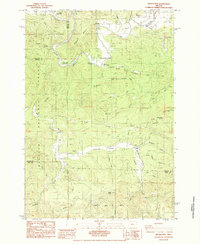
 1984 Prairie Peak1985 Print · USGSBenton and Lane counties are shown in the mid-eighties as a hub of timber and quarrying activity along the Coast Range. Researchers can locate active resource sites like Headrick Quarry, the Billy Tower lookout, and Herbert K. McBee Mem Park.
 - 1984 Map of Glenbrook, 1985 Print
 1984 Glenbrook1985 Print · USGSBenton and Lane Counties are captured in the mid-1980s as the logging and timber industry shaped the landscape. Genealogists and historians can trace the Old RR Grade, find the small settlements of Dawson and Glenbrook, or locate the Alsea Falls campground.
 - 1984 Map of Five Rivers, 1985 Print
 1984 Five Rivers1985 Print · USGSCoastal Oregon's deep woods and river valleys are captured here in the mid-1980s as they span three county lines. Genealogists and historians can locate the community of Paris, trace the Alsea River to the Denzer Bridge, and explore the reaches of Siuslaw National Forest.
 - 1985 Map of Alsea
 1985 Alsea1985 Print · USGSBenton County forest lands and the river valley around Alsea are captured in the mid-eighties as a hub of timber and natural resource management. Researchers can trace the river's path past the Alsea River Fish Hatchery or locate landmarks like Alsea Summit and Old Blue Mountain.
End of results
Showing maps 1-14 of 14
Top cities of Benton County
- Corvallis historical maps
- Philomath historical maps
- Monroe historical maps
- Adair Village historical maps
Frequently asked questions
- What are the different types of historical maps available for Benton County?
- What is the oldest map of Benton County?
- Where can I purchase historical maps of Benton County for my home or office?
- Where can I download high-res historical maps of Benton County?
- Are there historical topographic maps available for Benton County?
- Is there historical aerial imagery available for Benton County?
- Where are historical maps of Benton County sourced from?