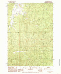
1984 Map of Prairie Peak
USGS Topo · Published 1985About this map
Prairie Mountain dominates the center of this 1984 survey, marking the high ground along the Benton Co Lane Co line. The landscape is defined by its industrial and recreational utility during the mid-1980s, featuring several extractive sites like Headrick Quarry and multiple Quarry and Borrow Pit locations. These operations are connected by a network of timber and access roads, including the Little Lobster Creek Road and Hull Oakes Rd, which snake through the complex drainages of Bummer Creek and Wilson Creek.
Find a feature on this map
39 named features on this map. Tap any name to fly to it.
Don’t see what you’re looking for? This feature index may not catch every label — zoom into the map to look around manually.
Map Details
Editions of this 1984 Prairie Peak Map
This is the sole edition of this map. No revisions or reprints were ever made.
Other maps of this area

1909 · Elmira
USGS Topo · 1:62,500

1922 · Monroe
USGS Topo · 1:62,500

1922 · Elmira
USGS Topo · 1:62,500

1939 · Monroe
USGS Topo · 1:62,500

1941 · Blachly
USGS Topo · 1:62,500

1942 · Alsea
USGS Topo · 1:62,500

1942 · Elmira
USGS Topo · 1:62,500

1942 · Blachly
USGS Topo · 1:62,500

1942 · Monroe
USGS Topo · 1:62,500

1953 · Salem
USGS Topo · 1:250,000