1950s Maps of Clatsop County, Oregon
Explore 17 historic maps of Clatsop County from the 1950s. These maps offer a rare glimpse into what life looked like during the 1950s — showing old roads, neighborhoods, homes, and landmarks that have changed or disappeared over time.
Whether you're researching your family's past, planning a metal detecting trip, or studying how Clatsop County's landscape evolved across the 1950s, these high-resolution maps are a powerful tool for exploring the history of this region.
- Focus on a specific era: All maps on this page are from the 1950s, giving you a focused view of this time period.
- See what’s changed: Compare century-old streets, trails, and buildings to today's modern landscape using overlays and satellite layers.
- Research with precision: Use these maps for genealogy, historical research, land use analysis, or educational projects.
- View, download, or print: Maps are fully viewable online in high resolution, and can be downloaded or printed for your own records.
Start exploring Clatsop County's history through authentic maps from the 1950s. This is your window into the past.
Clatsop County, OR maps
(17)- 1950 Map of Vancouver
 1950 Vancouver1950 Print · USGSCoastal Oregon and the lower Columbia River valley are captured in detail just after the war. Researchers can trace historic rail routes like the Southern Pacific or locate early settlements such as Vernonia, Gaston, and the Grand Ronde Indian Reservation.
 - 1950 Map of Vancouver, 1951 Print
 1950 Vancouver1951 Print · USGSThe Pacific Northwest urban corridor meets the rugged coast in the years following the war, showing the expansion of Portland and Vancouver. Genealogists and historians can trace the reach of the Southern Pacific RR and locate coastal communities like Tillamook, Seaside, and Tolovana Park.
 - 1951 Map of Copalis Beach
 1951 Copalis Beach1951 Print · USGSThe Olympic Peninsula's rugged coast and tribal lands are meticulously detailed in the early 1950s. Genealogists and historians can trace the foundations of coastal communities from Taholah to La Push or locate early markers like the James Island Lighthouse.
 - 1951 Map of Clatsop Spit, 1955 Print
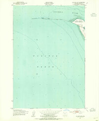 1951 Clatsop Spit1955 Print · USGSThe Oregon coast at the mouth of the Columbia River comes into sharp focus in the early fifties, showing the interplay of military grounds and maritime hazards. Locate the Lookout Tower on Clatsop Spit or trace the reach of the South Jetty.3 unique versions available
 - 1953 Map of Hoquiam
 1953 Hoquiam1953 Print · USGSSouthwest Washington in the early fifties shows a landscape shaped by timber, rail, and river commerce from the coast to the Cascades. Genealogists and historians can trace the development of timber towns like Ryderwood and the industrial hubs of Hoquiam and Kelso.2 unique versions available
 - 1953 Map of Skamokawa, 1955 Print
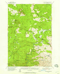
 1953 Skamokawa1955 Print · USGSThe riverfront culture of Wahkiakum County is on full display here in the early 1950s, showing the intersection of the Columbia River and the logging woods. Researchers can locate the Fern Hill Cem, the Blaney Lookout, and vanished infrastructure like the Dismantled RR.3 unique versions available
 - 1953 Map of Warrenton, 1955 Print
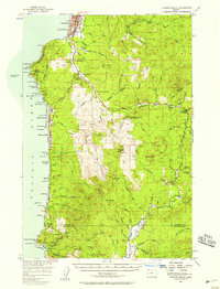
 1953 Warrenton1955 Print · USGSCoastal Oregon at the mouth of the Columbia River comes alive in the mid-fifties, showing the strategic military and maritime landscape. Trace the grounds of Fort Stevens, find the Soldiers Cem, or locate the Clatsop County Airport and old rail lines.6 unique versions available
 - 1953 Map of Cathlamet, 1955 Print
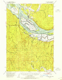 1953 Cathlamet1955 Print · USGSThe Lower Columbia River reaches a peak of commercial and timber activity during the early fifties. Genealogists and local historians can trace family roots through riverside settlements like Cathlamet and Westport, or find Greenwood Cem and Fishhawk Cem.4 unique versions available
 - 1955 Map of Saddle Mountain, 1957 Print
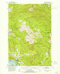
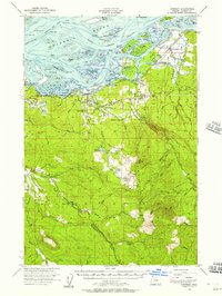
 1955 Saddle Mountain1957 Print · USGSIn the mid-1950s, the timber-rich mountains of Clatsop County were defined by the Nehalem River and the expansion of the Sunset Highway. Genealogists and historians can trace old community centers like Jewell and Elsie, or locate the Logging Railroad near Salmonberry River.3 unique versions available
 - 1955 Map of Svensen, 1957 Print
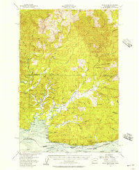
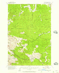
 1955 Svensen1957 Print · USGSThe Columbia River estuary in the mid-fifties is a landscape of complex waterways and timber-driven settlements. Genealogists and historians can trace family locations near Svensen, Brownsmead, and Forest Hill Cemetery or locate old industrial sites like the Klaskanine Fish Hatchery.3 unique versions available
 - 1955 Map of Grays River, 1957 Print
 1955 Grays River1957 Print · USGSCoastal Washington and the northern bank of the Columbia River are shown here in the mid-fifties, when timber and fishing drove the local economy. Researchers can locate the Grays River Cemetery, the Pillar Rock Cannery, and rural landmarks like the Dahlia Sch.3 unique versions available
 - 1955 Map of Birkenfeld, 1957 Print
 1955 Birkenfeld1957 Print · USGSCoastal Oregon timber country comes alive in the mid-fifties, showing the intersection of the logging industry and small rural outposts. Researchers can trace the Old Railroad Grade and locate vanished local landmarks like the Vesper Sch (Aban'd) and Camp McGregor.3 unique versions available
 - 1955 Map of Cannon Beach, 1958 Print
 1955 Cannon Beach1958 Print · USGSThe Oregon coast in the mid-1950s reveals a landscape of growing seaside towns and deep timber country. Genealogists and historians can trace family plots at Evergreen Cemetery or locate early landmarks like the Necanicum Guard Sta and Aldervale.2 unique versions available
 - 1957 Map of Hoquiam
 1957 Hoquiam1957 Print · USGSCoastal timber ports and inland rail hubs define Southwest Washington during the late fifties. Genealogists can trace early twentieth-century settlements like Bordeaux, Tono, and Cosmopolis alongside the expanding tracks of the Northern Pacific.
 - 1957 Map of Copalis Beach, 1968 Print
 1957 Copalis Beach1968 Print · USGSThe Washington coast during the late fifties reveals a landscape of tribal reservations and timber towns linked by the Northern Pacific RR. Trace family history and land patterns near Forks Cemetery, the shingle mill, or coastal landings like Taholah and Oysterville.2 unique versions available
 - 1958 Map of Vancouver, 1968 Print
 1958 Vancouver1968 Print · USGSThe Lower Columbia and Willamette valleys thrive in the late sixties as major rail and river hubs. Genealogists and historians can trace the development of Portland, identify the grounds of Camp Withycombe, and locate coastal landmarks from Tillamook Head to Garibaldi.3 unique versions available
 - 1958 Map of Hoquiam, 1969 Print
 1958 Hoquiam1969 Print · USGSSouthwest Washington and the Columbia River estuary appear here in the mid-century, before major landscape shifts. Researchers can trace the rail lines of the Northern Pacific, locate the Fort Henness Site, or explore the Naselle Air Force Station.2 unique versions available
End of results
Showing maps 1-17 of 17
Top cities of Clatsop County
- Astoria historical maps
- Seaside historical maps
- Warrenton historical maps
- Cannon Beach historical maps
- Gearhart historical maps
Frequently asked questions
- What are the different types of historical maps available for Clatsop County?
- What is the oldest map of Clatsop County?
- Where can I purchase historical maps of Clatsop County for my home or office?
- Where can I download high-res historical maps of Clatsop County?
- Are there historical topographic maps available for Clatsop County?
- Is there historical aerial imagery available for Clatsop County?
- Where are historical maps of Clatsop County sourced from?