1970s Maps of Clatsop County, Oregon
Explore 5 historic maps of Clatsop County from the 1970s. These maps offer a rare glimpse into what life looked like during the 1970s — showing old roads, neighborhoods, homes, and landmarks that have changed or disappeared over time.
Whether you're researching your family's past, planning a metal detecting trip, or studying how Clatsop County's landscape evolved across the 1970s, these high-resolution maps are a powerful tool for exploring the history of this region.
- Focus on a specific era: All maps on this page are from the 1970s, giving you a focused view of this time period.
- See what’s changed: Compare century-old streets, trails, and buildings to today's modern landscape using overlays and satellite layers.
- Research with precision: Use these maps for genealogy, historical research, land use analysis, or educational projects.
- View, download, or print: Maps are fully viewable online in high resolution, and can be downloaded or printed for your own records.
Start exploring Clatsop County's history through authentic maps from the 1970s. This is your window into the past.
Clatsop County, OR maps
(5)- 1979 Map of Sager Creek, 1980 Print
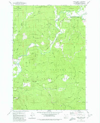 1979 Sager Creek1980 Print · USGSClatsop County timberlands and the upper Nehalem Valley are captured here in the late seventies. Family-named landmarks and forest camps invite discovery, from the homestead site at Doc Rankins Place to the industrial Buster Creek Quarry and the riverside community of Jewell.
 - 1979 Map of Birkenfeld, 1980 Print
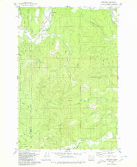 1979 Birkenfeld1980 Print · USGSThe Nehalem River corridor in the late 1970s reveals a landscape shaped by timber and ranching on the border of Clatsop and Columbia counties. Researchers can trace the layout of small valley settlements like Birkenfeld and Mist or locate sites like Boeck Ranch and the Cem.
 - 1979 Map of Clear Creek, 1980 Print
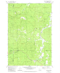 1979 Clear Creek1980 Print · USGSThe northern Coast Range comes alive in the late 1970s where four counties converge amidst the Clatsop State Forest. Researchers can trace old logging grades and family-named routes while locating historic sites like Keasey and the riverfront Cem.
 - 1979 Map of Sunset Spring, 1980 Print
 1979 Sunset Spring1980 Print · USGSCoastal Oregon highlands in the late seventies showcase a landscape of managed timberlands and industrial outposts. Local historians can trace the footprints of Camp McGregor (Site), locate the Sterling FS Station, or follow the winding North Fork Salmonberry River.2 unique versions available
 - 1979 Map of Nehalem River, 1980 Print
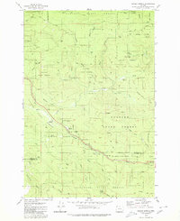
 1979 Nehalem River1980 Print · USGSThe northern Oregon coast and its timber-rich interior are captured here in the late seventies, showing the vital connection between sea and forest. Researchers can trace the rail lines of the Southern Pacific and Burlington Northern through historic logging hubs like Vernonia, Timber, and Nehalem.3 unique versions available
End of results
Showing maps 1-5 of 5
Top cities of Clatsop County
- Astoria historical maps
- Seaside historical maps
- Warrenton historical maps
- Cannon Beach historical maps
- Gearhart historical maps
Frequently asked questions
- What are the different types of historical maps available for Clatsop County?
- What is the oldest map of Clatsop County?
- Where can I purchase historical maps of Clatsop County for my home or office?
- Where can I download high-res historical maps of Clatsop County?
- Are there historical topographic maps available for Clatsop County?
- Is there historical aerial imagery available for Clatsop County?
- Where are historical maps of Clatsop County sourced from?