1960s Maps of Hood River County, Oregon
Explore 7 historic maps of Hood River County from the 1960s. These maps offer a rare glimpse into what life looked like during the 1960s — showing old roads, neighborhoods, homes, and landmarks that have changed or disappeared over time.
Whether you're researching your family's past, planning a metal detecting trip, or studying how Hood River County's landscape evolved across the 1960s, these high-resolution maps are a powerful tool for exploring the history of this region.
- Focus on a specific era: All maps on this page are from the 1960s, giving you a focused view of this time period.
- See what’s changed: Compare century-old streets, trails, and buildings to today's modern landscape using overlays and satellite layers.
- Research with precision: Use these maps for genealogy, historical research, land use analysis, or educational projects.
- View, download, or print: Maps are fully viewable online in high resolution, and can be downloaded or printed for your own records.
Start exploring Hood River County's history through authentic maps from the 1960s. This is your window into the past.
Hood River County, OR maps
(7)- 1962 Map of Cathedral Ridge, 1964 Print
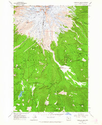
 1962 Cathedral Ridge1964 Print · USGSThe northern slopes of the Cascades are documented here in the early sixties, showing a landscape defined by active ice fields and early mountain tourism. Hikers and historians can trace the paths to Cloud Cap Inn, the Red Hill Guard Station, and the high waters of Dollar Lake.4 unique versions available
 - 1962 Map of Badger Lake, 1964 Print
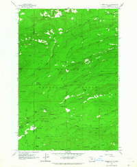
 1962 Badger Lake1964 Print · USGSThe high country of the Oregon Cascades comes into focus in the early sixties, showing the vital drainage basins and forest outposts of the day. Trace the network of trails and roads leading to Badger Lake, Robinhood Guard Sta, and Elk Meadows.3 unique versions available
 - 1962 Map of Dog River, 1964 Print
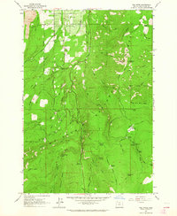 1962 Dog River1964 Print · USGSThe northern Cascades come into focus in the early sixties as forestry and water management shaped the region. Trace early recreational and utility sites like the Cooper Spur Ski Area and The Dalles City Waterworks Gaging Station near the Dog River.4 unique versions available
 - 1962 Map of Timberline Lodge, 1964 Print
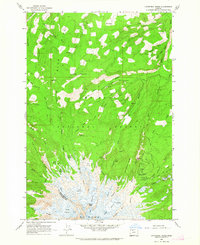
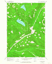
 1962 Timberline Lodge1964 Print · USGSMount Hood and its surrounding national forest in the early sixties reveal a landscape of glaciated peaks and rising alpine tourism. Trace historic transit routes like the Barlow Road and explore landmarks such as Timberline Lodge and Trillium Lake.3 unique versions available
 - 1962 Map of Fivemile Butte, 1964 Print
 1962 Fivemile Butte1964 Print · USGSWasco and Hood River counties are shown here in the early 1960s, documenting a landscape shaped by high-elevation forestry and old mountain routes. You can trace early logistics and recreation at Camp Baldwin, the Hollow Rail Road, and the Lookout Tower on Fivemile Butte.
 - 1962 Map of Bull Run Lake, 1964 Print
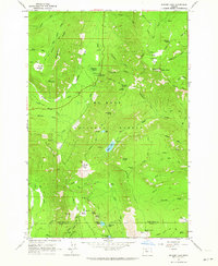
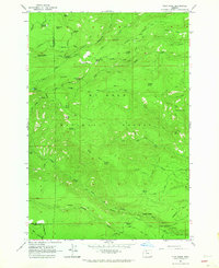
 1962 Bull Run Lake1964 Print · USGSMount Hood's wilderness and protected watersheds are captured in the early sixties, showing the rugged backcountry before modern development. Researchers can trace the path of the Skyline Trail and locate historic sites like the Ranger Station and Bals Mtn Shelter.3 unique versions available
 - 1962 Map of Flag Point, 1964 Print
 1962 Flag Point1964 Print · USGSThe high timber and alpine drainages of the Mount Hood National Forest are mapped here in the early sixties. Genealogists and historians can trace old mountain routes like the Bennett Pass Road and find early recreation sites such as Camp Friend and the Fifteenmile Campground.
End of results
Showing maps 1-7 of 7
Top cities of Hood River County
Frequently asked questions
- What are the different types of historical maps available for Hood River County?
- What is the oldest map of Hood River County?
- Where can I purchase historical maps of Hood River County for my home or office?
- Where can I download high-res historical maps of Hood River County?
- Are there historical topographic maps available for Hood River County?
- Is there historical aerial imagery available for Hood River County?
- Where are historical maps of Hood River County sourced from?