1970s Maps of Hood River County, Oregon
Explore 12 historic maps of Hood River County from the 1970s. These maps offer a rare glimpse into what life looked like during the 1970s — showing old roads, neighborhoods, homes, and landmarks that have changed or disappeared over time.
Whether you're researching your family's past, planning a metal detecting trip, or studying how Hood River County's landscape evolved across the 1970s, these high-resolution maps are a powerful tool for exploring the history of this region.
- Focus on a specific era: All maps on this page are from the 1970s, giving you a focused view of this time period.
- See what’s changed: Compare century-old streets, trails, and buildings to today's modern landscape using overlays and satellite layers.
- Research with precision: Use these maps for genealogy, historical research, land use analysis, or educational projects.
- View, download, or print: Maps are fully viewable online in high resolution, and can be downloaded or printed for your own records.
Start exploring Hood River County's history through authentic maps from the 1970s. This is your window into the past.
Hood River County, OR maps
(12)- 1974 Map of Parkdale, 1977 Print
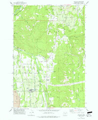 1974 Parkdale1977 Print · USGSHood River Valley life in the mid-1970s revolves around the orchard settlements of Parkdale and Odell. Genealogists and local historians can trace family-named landmarks like Shelley Cem, Dukes Valley, and the Farmers River Ditch across the landscape.
 - 1975 Map of Hood River NE, 1979 Print
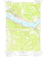
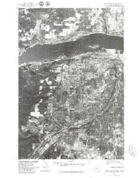 1975 Hood River NE1979 Print · USGSThe mid-seventies landscape of the Columbia River Gorge is captured in this detailed aerial survey. Researchers can trace the development of Hood River and Odell along with the winding course of the Hood River and the industrial riverfront.2 unique versions available
 - 1975 Map of White Salmon, 1980 Print
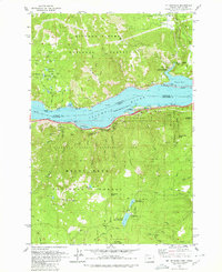
 1975 White Salmon1980 Print · USGSThe mid-1970s landscape of the Columbia River Gorge is captured here through detailed aerial photography. Genealogists and local historians can trace the street grids and rural boundaries of White Salmon, Bingen, and Mosier as they appeared decades ago.
 - 1977 Map of Ketchum Reservoir
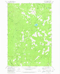
 1977 Ketchum Reservoir1977 Print · USGSThe Oregon Cascades foothills meet the Hood River and Wasco county line in the mid-1970s, showing a landscape defined by timber and vital water sources. Researchers can trace old mountain routes and water rights through features like Old Schoolhouse Spring, Ketchum Reservoir, and Sheldon Ridge.
 - 1978 Map of White Salmon
 1978 White Salmon1978 Print · USGSThe Columbia River Gorge in the late seventies reveals a bustling transportation corridor shared by Washington and Oregon. Researchers can trace the rail lines of the Northern Burlington, locate family plots at the IOOF Cem, or explore the old layout of White Salmon and Mosier.
 - 1979 Map of Badger Lake
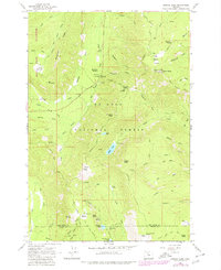 1979 Badger Lake1979 Print · USGSThe Mt Hood wilderness in the late seventies reveals a high-country network of forest service outposts and alpine trail systems. Researchers can trace historic sites like the Robinhood Guard Sta, the Valley View Cabin, and remote landmarks like Badger Lake.
 - 1979 Map of Bonneville Dam
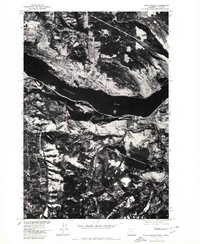
 1979 Bonneville Dam1979 Print · USGSThe Columbia River Gorge in the late seventies reveals a landscape of massive hydroelectric works and timbered peaks. Genealogists and historians can trace the riverside towns of Stevenson and Cascade Locks or locate the site of the Bonneville Dam.
 - 1979 Map of Mt. Defiance, 1980 Print
 1979 Mt. Defiance1980 Print · USGSThe Columbia River Gorge in the late seventies reveals a landscape of industrial activity and recreational growth. Trace the river's rail-and-timber history through the Little White Salmon National Fish Hatchery and the twin sites of Mill A and Mill B.2 unique versions available
 - 1979 Map of Hood River, 1980 Print
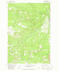
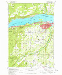 1979 Hood River1980 Print · USGSThe Columbia River corridor thrives in the late seventies as a hub of transport and agriculture. Trace local family roots and early infrastructure at Idelwilde Cem, Frankton Sch, and the Powerdale Dam.
 - 1979 Map of Wahtum Lake, 1980 Print
 1979 Wahtum Lake1980 Print · USGSThe high ridges of the Cascades are documented here in the late seventies, detailing the extensive backcountry trail network of the Mount Hood National Forest. Hikers and historians can trace the Pacific Crest National Scenic Trail past Wahtum Lake and find remote sites like Indian Springs Campground and Wy'East Campsite.2 unique versions available
 - 1979 Map of Dee, 1980 Print
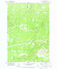
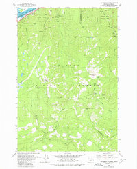
 1979 Dee1980 Print · USGSThe Hood River valley in the late seventies is centered on the logging and rail infrastructure of Dee. Genealogists and industrial historians can trace the Mount Hood Railroad corridor, the community of Winans, and the complex water systems near Punchbowl Falls.
 - 1979 Map of Tanner Butte, 1980 Print
 1979 Tanner Butte1980 Print · USGSThe wilderness of the Columbia River Gorge in the late seventies reveals a landscape of waterfalls and timberlands. Outdoor enthusiasts and researchers can trace the Union Pacific rail line, find remote mountain camps at Tenas Camp Falls, and locate summits like Tanner Butte and Mt Talapus.2 unique versions available
End of results
Showing maps 1-12 of 12
Top cities of Hood River County
Frequently asked questions
- What are the different types of historical maps available for Hood River County?
- What is the oldest map of Hood River County?
- Where can I purchase historical maps of Hood River County for my home or office?
- Where can I download high-res historical maps of Hood River County?
- Are there historical topographic maps available for Hood River County?
- Is there historical aerial imagery available for Hood River County?
- Where are historical maps of Hood River County sourced from?