1974 Map of Parkdale
USGS Topo · Published 1977About this map
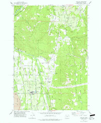
The settlement of Parkdale anchors the southern portion of this Hood River Valley landscape, serving as a hub for the surrounding orchards and timberlands. In the mid-1970s, the region was defined by its sophisticated water management and transport networks, including the Farmers River Ditch and the Union Pacific rail line. The terrain rises sharply toward Middle Mountain and Booth Hill, while the East Fork Hood River carves through the valley floor. Genealogy researchers will find the Upper Valley Cem near the town center and Shelley Cem to the northeast. Local industry and infrastructure are represented by features like the Hanel Airstrip, several Gravel Pits, and the Hood River Valley Ranger Station, reflecting a period when the valley's economy balanced recreation at Zira Dimmick State Park with active resource management.
Find a feature on this map
70 named features on this map. Tap any name to fly to it.
Don’t see what you’re looking for? This feature index may not catch every label — zoom into the map to look around manually.
Map Details
Editions of this 1974 Parkdale Map
This is the sole edition of this map. No revisions or reprints were ever made.
Other maps of this area

1924 · Mount Hood
USGS Topo · 1:125,000

1926 · Hood River
USGS Topo · 1:125,000

1927 · Mount Hood
USGS Topo · 1:125,000

1929 · Hood River
USGS Topo · 1:125,000

1930 · Dufur
USGS Topo · 1:125,000

1934 · Dufur
USGS Topo · 1:125,000

1934 · The Dalles
USGS Topo · 1:125,000

1953 · The Dalles
USGS Topo · 1:250,000

1956 · The Dalles
USGS Topo · 1:250,000

1957 · The Dalles
USGS Topo · 1:250,000