1940s Maps of Jackson County, Oregon
Explore 4 historic maps of Jackson County from the 1940s. These maps offer a rare glimpse into what life looked like during the 1940s — showing old roads, neighborhoods, homes, and landmarks that have changed or disappeared over time.
Whether you're researching your family's past, planning a metal detecting trip, or studying how Jackson County's landscape evolved across the 1940s, these high-resolution maps are a powerful tool for exploring the history of this region.
- Focus on a specific era: All maps on this page are from the 1940s, giving you a focused view of this time period.
- See what’s changed: Compare century-old streets, trails, and buildings to today's modern landscape using overlays and satellite layers.
- Research with precision: Use these maps for genealogy, historical research, land use analysis, or educational projects.
- View, download, or print: Maps are fully viewable online in high resolution, and can be downloaded or printed for your own records.
Start exploring Jackson County's history through authentic maps from the 1940s. This is your window into the past.
Jackson County, OR maps
(4)- 1943 Map of Trail, 1945 Print
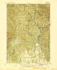 1943 Trail1945 Print · USGSJackson County during the mid-forties reveals a landscape transitioning from remote ranching to significant military and forestry use. Genealogists and historians can locate early family sites like Younkers Ranch, trace the Mountain King Mine, or find the Reese Creek Sch near the Rogue River.4 unique versions available
 - 1944 Map of Tiller, 1946 Print
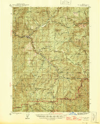 1944 Tiller1946 Print · USGSDouglas County and Jackson County meet along high ridges during the mid-1940s, where remote ranching and timber mills defined the South Umpqua valley. Researchers can trace family homesteads like Lucas Ranch or search for old industrial sites such as the Banfield Mine and Old Johnson Mill.5 unique versions available
 - 1944 Map of Abbott Butte, 1958 Print
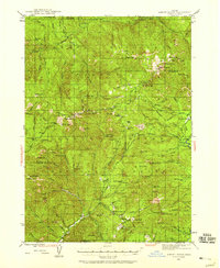 1944 Abbott Butte1958 Print · USGSSouthern Oregon's high timber country is documented here in the mid-1940s, showing the intersection of the Rogue River and Umpqua National Forests. Genealogists and historians can trace isolated mountain life through Ash Homestead, the Al Sarena (Buzzard) Mine, and several historic ranger stations.3 unique versions available
 - 1947 Map of Abbott Butte
 1947 Abbott Butte1947 Print · USGSThe Oregon Cascades during the 1940s reveal a high-country landscape of ranger stations, mining claims, and early homesteads. Researchers can locate remote sites like the Al Sarena (Buzzard) Mine and the Ash Homestead or trace the Rogue River Trail.2 unique versions available
End of results
Showing maps 1-4 of 4
Top cities of Jackson County
- Medford historical maps
- Ashland historical maps
- Central Point historical maps
- Eagle Point historical maps
- White City historical maps
- Talent historical maps
See more
Frequently asked questions
- What are the different types of historical maps available for Jackson County?
- What is the oldest map of Jackson County?
- Where can I purchase historical maps of Jackson County for my home or office?
- Where can I download high-res historical maps of Jackson County?
- Are there historical topographic maps available for Jackson County?
- Is there historical aerial imagery available for Jackson County?
- Where are historical maps of Jackson County sourced from?