1990s Maps of Jackson County, Oregon
Explore 38 historic maps of Jackson County from the 1990s. These maps offer a rare glimpse into what life looked like during the 1990s — showing old roads, neighborhoods, homes, and landmarks that have changed or disappeared over time.
Whether you're researching your family's past, planning a metal detecting trip, or studying how Jackson County's landscape evolved across the 1990s, these high-resolution maps are a powerful tool for exploring the history of this region.
- Focus on a specific era: All maps on this page are from the 1990s, giving you a focused view of this time period.
- See what’s changed: Compare century-old streets, trails, and buildings to today's modern landscape using overlays and satellite layers.
- Research with precision: Use these maps for genealogy, historical research, land use analysis, or educational projects.
- View, download, or print: Maps are fully viewable online in high resolution, and can be downloaded or printed for your own records.
Start exploring Jackson County's history through authentic maps from the 1990s. This is your window into the past.
Jackson County, OR maps
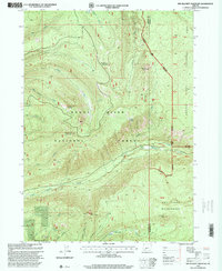
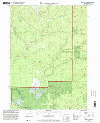
(38)- 1996 Map of Dutchman Peak, 1998 Print
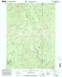
 1996 Dutchman Peak1998 Print · USGSThe Oregon-California borderlands are captured here in the mid-nineties, showing the high-altitude trails and ranching outposts of the Siskiyou range. Researchers can trace the Pacific Crest National Scenic Trail as it passes the Grubstake Mine and Beaver Ranch.
 - 1996 Map of Talent, 1998 Print
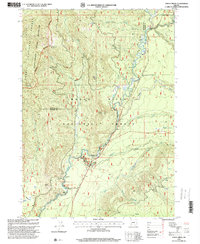
 1996 Talent1998 Print · USGSThe valley surrounding Talent is shown here in the mid-nineties, balancing its rail and highway corridors with an extensive irrigation network. Genealogists and local historians can locate Brickpile Ranch, trace the Southern Pacific line, or explore the heights of Bald Mountain.
 - 1996 Map of Sterling Creek, 1998 Print
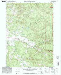
 1996 Sterling Creek1998 Print · USGSThe Buncom area in the mid-1990s reveals a landscape shaped by both forest management and historic mining. Researchers can trace land use through the Tailings along Sterling Creek, the local Cem, and the remote Barr Ranch.
 - 1996 Map of Tallowbox Mountain, 1998 Print
 1996 Tallowbox Mountain1998 Print · USGSThe Josephine and Jackson County line runs through this mountainous terrain in the late nineties. Genealogists and historians can locate old mining sites like the Star Mine and Maid of the Mist Mine or trace family landmarks such as Jim Mee Peak.
 - 1996 Map of Carberry Creek, 1998 Print
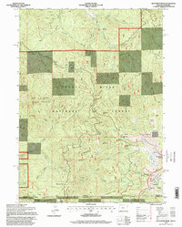
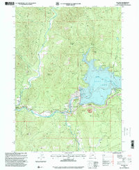
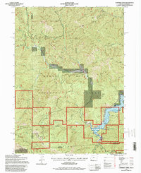 1996 Carberry Creek1998 Print · USGSThe Oregon-California borderlands were a landscape of active mining and mountain ranching in the late twentieth century. Genealogists and historians can trace the Steamboat (Site), locate the Steamboat Mine, or find the secluded Cem near Applegate Lake.
 - 1996 Map of Squaw Lakes, 1998 Print
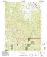
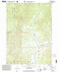
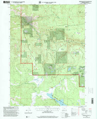
 1996 Squaw Lakes1998 Print · USGSThe border of Oregon and California comes alive in this mid-nineties survey of the high forest and the Applegate River valley. Researchers can pinpoint the former site of the Detroit Mine, the waters of Squaw Lakes, and the changed shoreline around Applegate Dam.
 - 1996 Map of Ashland, 1998 Print
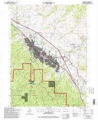 1996 Ashland1998 Print · USGSThe Bear Creek valley and the northern Siskiyou foothills are shown here in the mid-1990s. Local researchers can trace the growth of Ashland near Southern Oregon State College and landmark features like Pompadour Bluff or the Jackson Hot Springs.
 - 1996 Map of Ruch, 1998 Print
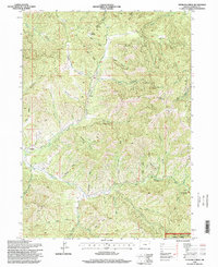
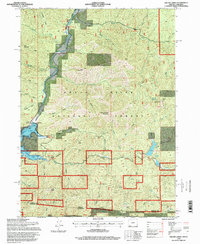
 1996 Ruch1998 Print · USGSThe Applegate Valley in the mid-1990s is shown here as a landscape of timbered peaks and riverside settlements. Genealogists and hikers can locate family-named landmarks like Offenbacher Point and historical crossings like McKee Bridge.
 - 1996 Map of King Mountain, 1999 Print
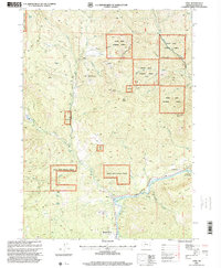
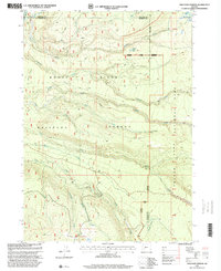
 1996 King Mountain1999 Print · USGSThe high peaks of southern Oregon were a hub for mineral exploration and modern communications in the mid-1990s. Genealogists and historians can trace old mining claims and landmarks like Quartzmill Peak, Ark Prairie, and a Placer Mine along Grave Creek.
 - 1996 Map of Wimer, 1999 Print
 1996 Wimer1999 Print · USGSEvans Valley at the close of the twentieth century shows a landscape where timber and agriculture meet. Genealogists and historians can trace local landmarks like Wimer, the Pleasant Creek Forest Station, and the private Spring Brook Airport.
 - 1997 Map of Mc Leod, 2000 Print
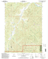
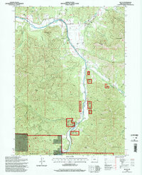
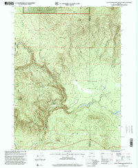
 1997 Mc Leod2000 Print · USGSJackson County's upper river landscape is captured here in the late nineties, showcasing the complex infrastructure surrounding the reservoir. Researchers can trace the layout of McLeod and find local landmarks like the Elk Trail Sch or the Cole M Rivers Fish Hatchery.
 - 1997 Map of Prospect South, 2000 Print
 1997 Prospect South2000 Print · USGSThe timber and hydroelectric landscape of the upper Rogue River comes into focus in the late 1990s. Researchers can trace the water systems of the aqueduct network, locate family holdings like Mill-Mar Ranch, or study forest service history at Lodgepole Guard Station.
 - 1997 Map of Lakecreek, 2000 Print
 1997 Lakecreek2000 Print · USGSJackson County ranching and water management come into focus in the late nineties as the forks of the Little Butte Creek meet near Lakecreek. Genealogists and local historians can trace family-named landmarks like Gardener Butte and find small burial sites marked as Cem or Graves.
 - 1997 Map of Rustler Peak, 2000 Print
 1997 Rustler Peak2000 Print · USGSThe high Cascade Range of Jackson County comes into focus in the late nineties, centered on the lookout at Rustler Peak. Trace the remote water systems of the Sky Lakes Wilderness and identify historic landmarks like Parker Meadows and the Pacific Crest National Scenic Trail.
 - 1997 Map of Cascade Gorge, 2000 Print
 1997 Cascade Gorge2000 Print · USGSThe Rogue River watershed in Jackson County is shown here in the late nineties, centered on the Cascade Gorge and Lost Creek Lake. Genealogists and hikers can locate the small Cem near the river or trace the old roads around Joseph Stewart State Park.
 - 1997 Map of Union Creek, 2000 Print
 1997 Union Creek2000 Print · USGSThe Cascades of the late nineties are defined here by the powerful waters of the Rogue River and the wilderness of the Umpqua National Forest. Researchers can trace the river's geological path through the Natural Bridge, locate the mountain settlement at Union Creek, and find family-named landmarks like Woodruff Meadow.
 - 1997 Map of Robinson Butte, 2000 Print
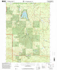
 1997 Robinson Butte2000 Print · USGSHigh in the Cascades during the late nineties, this landscape shows the intersection of timber management and recreation. Researchers can trace the water systems of Howard Prairie Lake or locate family sites like Dahak Ranch and the community of Deadwood.
 - 1997 Map of Trail, 2000 Print
 1997 Trail2000 Print · USGSThe Rogue River corridor comes into focus in the late nineties as it flows through the timberlands of Jackson County. Genealogists and local historians can locate the old Cem, trace the winding path of the Trail north of Shady Cove, or explore landmarks like Sugarloaf Mountain and Rogue Elk.
 - 1997 Map of Red Blanket Mountain, 2000 Print
 1997 Red Blanket Mountain2000 Print · USGSJackson and Klamath counties are shown here during the late nineties as a dense network of wilderness and national forest lands. Researchers can trace the drainages of Red Blanket Creek and Ginkgo Creek or locate landmarks like Bessie Rock and Rooktop Butte.
 - 1997 Map of Little Chinquapin Mountain, 2000 Print
 1997 Little Chinquapin Mountain2000 Print · USGSThe Southern Oregon Cascades meet at the Jackson and Klamath county line in the late nineties, where the Pacific Crest Trail winds past Grizzly Prairie. Trace the network of mountain waters from Big Springs to Jenny Creek or locate the site of the Cinder Pit.
 - 1997 Map of Willow Lake, 2000 Print
 1997 Willow Lake2000 Print · USGSJackson County's high forest country is captured here during the late nineties, centered on the Willow Lake recreation area. Researchers can identify old homesteading and logging traces through Swede Cabin Ruins, Camp 2, and family-named landmarks like Bieberstedt Butte.
 - 1997 Map of Thousand Springs, 2000 Print
 1997 Thousand Springs2000 Print · USGSThe Southern Cascades near the Jackson and Klamath county lines appear in the 1990s as a landscape of timber and springs. Researchers can locate the site of Wagon Camp, trace the numerous flows at Thousand Springs, or study the terrain around Huckleberry Mtn.
 - 1997 Map of Big Butte Springs, 2000 Print
 1997 Big Butte Springs2000 Print · USGSJackson County’s high timber country is shown in the late nineties, documenting the critical water infrastructure of the Rogue River basin. Researchers can trace the Medford Underground Aqueduct or locate historical sites like Camp 4 (Site) and the Oden Ranch.
 - 1997 Map of Imnaha Creek, 2000 Print
 1997 Imnaha Creek2000 Print · USGSThe High Cascades near the Jackson and Klamath county line are shown in the late nineties as a dense network of forest drainages and wilderness peaks. Researchers can trace the path of the Middle Fork Rogue River and locate specific sites like King Spruce (Site) or Mudjekeewis Mtn.
 - 1997 Map of Whetstone Point, 2000 Print
 1997 Whetstone Point2000 Print · USGSJackson County, Oregon is seen here during the late nineties, documenting the remote reaches of the Rogue River National Forest. Genealogists and historians can trace pioneer footprints at the Ash Homestead or locate high-country landmarks like White Point Lookout and the Al Serena Buzzard Mine.
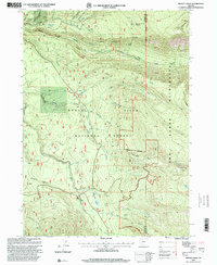
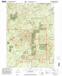
Showing maps 1-25 of 38
Top cities of Jackson County
- Medford historical maps
- Ashland historical maps
- Central Point historical maps
- Eagle Point historical maps
- White City historical maps
- Talent historical maps
See more
Frequently asked questions
- What are the different types of historical maps available for Jackson County?
- What is the oldest map of Jackson County?
- Where can I purchase historical maps of Jackson County for my home or office?
- Where can I download high-res historical maps of Jackson County?
- Are there historical topographic maps available for Jackson County?
- Is there historical aerial imagery available for Jackson County?
- Where are historical maps of Jackson County sourced from?