1970s Maps of Josephine County, Oregon
Explore 2 historic maps of Josephine County from the 1970s. These maps offer a rare glimpse into what life looked like during the 1970s — showing old roads, neighborhoods, homes, and landmarks that have changed or disappeared over time.
Whether you're researching your family's past, planning a metal detecting trip, or studying how Josephine County's landscape evolved across the 1970s, these high-resolution maps are a powerful tool for exploring the history of this region.
- Focus on a specific era: All maps on this page are from the 1970s, giving you a focused view of this time period.
- See what’s changed: Compare century-old streets, trails, and buildings to today's modern landscape using overlays and satellite layers.
- Research with precision: Use these maps for genealogy, historical research, land use analysis, or educational projects.
- View, download, or print: Maps are fully viewable online in high resolution, and can be downloaded or printed for your own records.
Start exploring Josephine County's history through authentic maps from the 1970s. This is your window into the past.
Josephine County, OR maps
(2)- 1974 Map of Grants Pass NW, 1977 Print
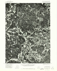 1974 Grants Pass NW1977 Print · USGSThe confluence of the Rogue and Applegate rivers is captured here during the mid-1970s, showing the intersection of Oregon timberland and valley agriculture. Researchers can trace the exact 1974 layout of Wilderville and the winding banks of the Rogue River.
 - 1974 Map of Grants Pass NE, 1979 Print
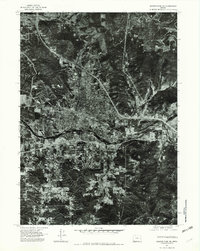 1974 Grants Pass NE1979 Print · USGSGrants Pass is captured during a mid-seventies period of expansion as the city spans the banks of the Rogue River. Researchers can trace the layout of residential neighborhoods and industrial sites near Gilbert Creek and Grants Pass Peak.2 unique versions available
End of results
Showing maps 1-2 of 2
Top cities of Josephine County
Frequently asked questions
- What are the different types of historical maps available for Josephine County?
- What is the oldest map of Josephine County?
- Where can I purchase historical maps of Josephine County for my home or office?
- Where can I download high-res historical maps of Josephine County?
- Are there historical topographic maps available for Josephine County?
- Is there historical aerial imagery available for Josephine County?
- Where are historical maps of Josephine County sourced from?