1950s Maps of Klamath Falls, Oregon
Explore 6 historic maps of Klamath Falls from the 1950s. These maps offer a rare glimpse into what life looked like during the 1950s — showing old roads, neighborhoods, homes, and landmarks that have changed or disappeared over time.
Whether you're researching your family's past, planning a metal detecting trip, or studying how Klamath Falls's landscape evolved across the 1950s, these high-resolution maps are a powerful tool for exploring the history of this region.
- Focus on a specific era: All maps on this page are from the 1950s, giving you a focused view of this time period.
- See what’s changed: Compare century-old streets, trails, and buildings to today's modern landscape using overlays and satellite layers.
- Research with precision: Use these maps for genealogy, historical research, land use analysis, or educational projects.
- View, download, or print: Maps are fully viewable online in high resolution, and can be downloaded or printed for your own records.
Start exploring Klamath Falls's history through authentic maps from the 1950s. This is your window into the past.
Klamath Falls, OR maps
(6)- 1955 Map of Klamath Falls, 1963 Print
 1955 Klamath Falls1963 Print · USGSSouthern Oregon's high desert and timber country are captured here during the mid-fifties, showing the rail-dependent economies of the basin. Genealogists and researchers can locate old outposts like the Keno Guard Station, the Bly Ranger Station, and the campus of the Oregon Technical Institute.4 unique versions available
 - 1957 Map of Merrill, 1959 Print
 1957 Merrill1959 Print · USGSThe Klamath Basin comes into sharp focus during the late fifties as irrigation and rail infrastructure reshaped the high desert. Researchers can trace the routes of the Southern Pacific, find early school sites like Shasta School, and locate the historic Stone Bridge crossing.2 unique versions available
 - 1957 Map of Swan Lake, 1959 Print
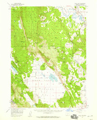 1957 Swan Lake1959 Print · USGSThe Klamath basin in the late fifties was a landscape of high plateaus and ranching valleys served by the California and Oregon Eastern railroad. Local historians can locate specific family landmarks like Gabriel Cem, Horton, and the early campus of the Oregon Technical Institute.3 unique versions available
 - 1957 Map of Klamath Falls, 1960 Print
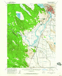 1957 Klamath Falls1960 Print · USGSThe Klamath Basin in the late fifties is defined by its complex water systems and burgeoning aviation and timber industries. Researchers can trace the rail corridors of the Great Northern RR and find landmarks like Kingsley Field or Teeters Landing.2 unique versions available
 - 1957 Map of Modoc Point, 1966 Print
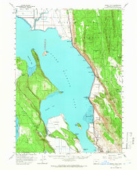 1957 Modoc Point1966 Print · USGSUpper Klamath Lake in the mid-fifties reveals a landscape of industrial timber sites and tribal lands along the Southern Pacific line. Researchers can trace the Algoma Incline (Site), locate family roots near David Hill Cem, and explore the reclaimed expanses of Caledonia Marsh.2 unique versions available
 - 1958 Map of Klamath Falls
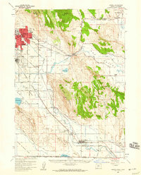
 1958 Klamath Falls1958 Print · USGSSouthern Oregon and the California borderlands are captured here in the mid-1950s during a peak era for the region's timber and rail industries. Trace the historic Klamath Indian Reservation boundaries and the rail lines of the Great Northern RR and the Oregon California and Eastern RR that connected remote towns like Bly and Beatty.3 unique versions available
End of results
Showing maps 1-6 of 6
Top cities near Klamath Falls
Top neighborhoods of Klamath Falls
Frequently asked questions
- What are the different types of historical maps available for Klamath Falls?
- What is the oldest map of Klamath Falls?
- Where can I purchase historical maps of Klamath Falls for my home or office?
- Where can I download high-res historical maps of Klamath Falls?
- Are there historical topographic maps available for Klamath Falls?
- Is there historical aerial imagery available for Klamath Falls?
- Where are historical maps of Klamath Falls sourced from?