1950s Maps of Eugene, Oregon
Explore 5 historic maps of Eugene from the 1950s. These maps offer a rare glimpse into what life looked like during the 1950s — showing old roads, neighborhoods, homes, and landmarks that have changed or disappeared over time.
Whether you're researching your family's past, planning a metal detecting trip, or studying how Eugene's landscape evolved across the 1950s, these high-resolution maps are a powerful tool for exploring the history of this region.
- Focus on a specific era: All maps on this page are from the 1950s, giving you a focused view of this time period.
- See what’s changed: Compare century-old streets, trails, and buildings to today's modern landscape using overlays and satellite layers.
- Research with precision: Use these maps for genealogy, historical research, land use analysis, or educational projects.
- View, download, or print: Maps are fully viewable online in high resolution, and can be downloaded or printed for your own records.
Start exploring Eugene's history through authentic maps from the 1950s. This is your window into the past.
Eugene, OR maps
(5)- 1953 Map of Salem
 1953 Salem1953 Print · USGSMid-century Oregon comes to life through this detailed survey of the Willamette Valley and the adjacent Pacific coastline. Researchers can trace the rail lines of the Southern Pacific RR, visit rural hubs like Fairview School, or locate coastal landmarks like the Yaquina Head Lighthouse.
 - 1954 Map of Salem
 1954 Salem1954 Print · USGSMid-century Western Oregon is centered on the productive Willamette River valley as its cities and infrastructure expand toward the mountains. Genealogists and historians can trace the rail lines of the Southern Pacific RR and Oregon Electric Ry through towns like Dallas, Independence, and Brownsville.
 - 1957 Map of Cottage Grove, 1960 Print
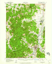 1957 Cottage Grove1960 Print · USGSCottage Grove and the southern Willamette Valley are captured here in the late fifties as timber and rail still drove the local economy. Genealogists and historians can locate numerous rural schoolhouses like Silk Creek School and trace the Southern Pacific line through Saginaw and Latham.2 unique versions available
 - 1958 Map of Roseburg, 1960 Print
 1958 Roseburg1960 Print · USGSThe timber valleys and high volcanic peaks of Southern Oregon are captured here in the late fifties. Researchers can trace the Southern Pacific rail line through historic settlements like Cottage Grove, Yoncalla, and Oakridge near the Cascade Range crest.4 unique versions available
 - 1959 Map of Roseburg
 1959 Roseburg1959 Print · USGSThe Umpqua and Willamette valleys meet the high Cascades in this late-fifties study of Southern Oregon's timber and rail corridors. Genealogists and researchers can trace the Southern Pacific RR through historic towns like Roseburg, Yoncalla, and Cottage Grove.
End of results
Showing maps 1-5 of 5
Top cities near Eugene
- Springfield historical maps
- Junction City historical maps
- Creswell historical maps
- Veneta historical maps
- Harrisburg historical maps
- Coburg historical maps
See more
Top neighborhoods of Eugene
- Danebo historical maps
- College Hill historical maps
- Santa Clara historical maps
- Bethel historical maps
- North Country Townhouses historical maps
- Chase Commons Safe Sleep Site historical maps
See more
Frequently asked questions
- What are the different types of historical maps available for Eugene?
- What is the oldest map of Eugene?
- Where can I purchase historical maps of Eugene for my home or office?
- Where can I download high-res historical maps of Eugene?
- Are there historical topographic maps available for Eugene?
- Is there historical aerial imagery available for Eugene?
- Where are historical maps of Eugene sourced from?