1980s Maps of Keizer, Oregon
Explore 3 historic maps of Keizer from the 1980s. These maps offer a rare glimpse into what life looked like during the 1980s — showing old roads, neighborhoods, homes, and landmarks that have changed or disappeared over time.
Whether you're researching your family's past, planning a metal detecting trip, or studying how Keizer's landscape evolved across the 1980s, these high-resolution maps are a powerful tool for exploring the history of this region.
- Focus on a specific era: All maps on this page are from the 1980s, giving you a focused view of this time period.
- See what’s changed: Compare century-old streets, trails, and buildings to today's modern landscape using overlays and satellite layers.
- Research with precision: Use these maps for genealogy, historical research, land use analysis, or educational projects.
- View, download, or print: Maps are fully viewable online in high resolution, and can be downloaded or printed for your own records.
Start exploring Keizer's history through authentic maps from the 1980s. This is your window into the past.
Keizer, OR maps
(3)- 1980 Map of Yamhill River
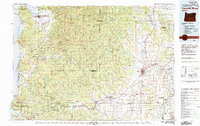 1980 Yamhill River1980 Print · USGSThe Oregon Coast Range and the western Willamette Valley meet in this 1980 survey, showing the landscape from the Pacific shore to the valley floor. Genealogists and historians can trace old routes like the Salmon River Highway to find the Grand Ronde Agency, Cloverdale, and Perrydale.3 unique versions available
 - 1980 Map of Corvallis, 1981 Print
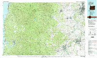 1980 Corvallis1981 Print · USGSThe Oregon Coast Range meets the fertile Willamette Valley in the early eighties, documenting a landscape of timber, agriculture, and growing college towns. Genealogists and historians can trace old rail lines like the Southern Pacific or locate landmarks like Marys Peak and the College of Education.
 - 1982 Map of Oregon City, 1983 Print
 1982 Oregon City1983 Print · USGSGreater Portland and the Willamette Valley are shown in the early eighties as the region's urban and rural landscapes converged. Genealogists and historians can trace family-named sites across French Prairie, visit St Paul Ch, or locate the grounds of Dammasch State Hospital.
End of results
Showing maps 1-3 of 3
Top cities near Keizer
- Salem historical maps
- McMinnville historical maps
- Woodburn historical maps
- Monmouth historical maps
- Silverton historical maps
- Independence historical maps
See more
Top neighborhoods of Keizer
Frequently asked questions
- What are the different types of historical maps available for Keizer?
- What is the oldest map of Keizer?
- Where can I purchase historical maps of Keizer for my home or office?
- Where can I download high-res historical maps of Keizer?
- Are there historical topographic maps available for Keizer?
- Is there historical aerial imagery available for Keizer?
- Where are historical maps of Keizer sourced from?