1970s Maps of Polk County, Oregon
Explore 14 historic maps of Polk County from the 1970s. These maps offer a rare glimpse into what life looked like during the 1970s — showing old roads, neighborhoods, homes, and landmarks that have changed or disappeared over time.
Whether you're researching your family's past, planning a metal detecting trip, or studying how Polk County's landscape evolved across the 1970s, these high-resolution maps are a powerful tool for exploring the history of this region.
- Focus on a specific era: All maps on this page are from the 1970s, giving you a focused view of this time period.
- See what’s changed: Compare century-old streets, trails, and buildings to today's modern landscape using overlays and satellite layers.
- Research with precision: Use these maps for genealogy, historical research, land use analysis, or educational projects.
- View, download, or print: Maps are fully viewable online in high resolution, and can be downloaded or printed for your own records.
Start exploring Polk County's history through authentic maps from the 1970s. This is your window into the past.
Polk County, OR maps
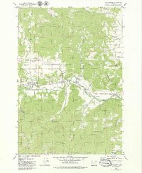
(14)- 1970 Map of Monmouth, 1972 Print
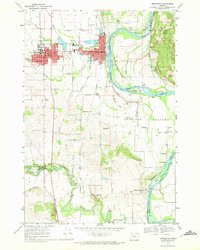 1970 Monmouth1972 Print · USGSThe Willamette Valley comes alive in the early seventies, showing the established campus of Oregon College of Education and the riverfront at Independence. Genealogists and historians can trace the Southern Pacific tracks, local schools like Talmadge Jr High Sch, and riverside points including Wigrich Landing.2 unique versions available
 - 1970 Map of Lewisburg, 1972 Print
 1970 Lewisburg1972 Print · USGSBenton County's mid-century landscape is preserved here as it transitioned from a military center to a game management area. Genealogists can locate Gingles Cem and Locke Cem, or trace the tracks of the Southern Pacific and Oregon Electric railroads.3 unique versions available
 - 1970 Map of Sidney, 1972 Print
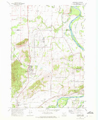
 1970 Sidney1972 Print · USGSMarion County south of Salem is shown here in the early seventies as a rich agricultural and riparian landscape. Genealogists can locate family names and burial sites at Rosedale Cem and Looney Cem or trace the old Oregon Electric rail line through Talbot and Sidney.3 unique versions available
 - 1973 Map of Socialist Valley, 1977 Print
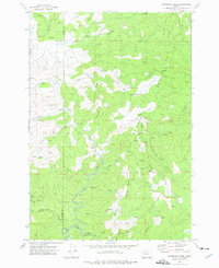
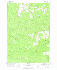
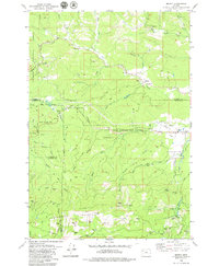
 1973 Socialist Valley1977 Print · USGSThe timberlands and watersheds of Polk County come into focus in the early seventies. Genealogists and local historians can trace the Old German Brethren Ch, the Socialist Valley settlement, and the Aaron Mercer Reservoir.
 - 1974 Map of Warnicke Creek, 1976 Print
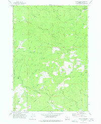
 1974 Warnicke Creek1976 Print · USGSThe rugged timberlands along the Polk and Lincoln county line are captured here in the mid-seventies. Researchers can trace logging access via Murphy Road and locate landmarks like Rooster Rock, Sugarloaf Mountain, and Stott Mtn.
 - 1974 Map of Fanno Ridge, 1977 Print
 1974 Fanno Ridge1977 Print · USGSPolk County forestry and river life are recorded here in the mid-1970s. Trace the timber history at Black Rock or explore the boundaries of the Geo B Gerlinger State Experimental Forest along the Little Luckiamute River.
 - 1974 Map of Airlie North, 1977 Print
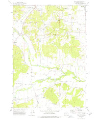 1974 Airlie North1977 Print · USGSPolk County agriculture and river-valley transport are captured here in the mid-1970s. Researchers can trace the Valley and Siletz rail line and locate pioneer-era sites like the Hart-Riggs Cem and the settlement of Lewisville.
 - 1974 Map of Falls City, 1977 Print
 1974 Falls City1977 Print · USGSThe Luckiamute River valley in Polk County is captured here in the mid-1970s, showcasing a landscape of timber management and small riverfront settlements. Genealogists and historians can locate legacy sites like Odd Fellows Cem, Oakhurst School, and the Old Railroad Grade.
 - 1974 Map of Dallas, 1977 Print
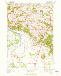
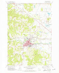 1974 Dallas1977 Print · USGSDallas and its surrounding Polk County countryside are captured here in the mid-seventies, showing the intersection of the Southern Pacific line and Rickreall Creek. Researchers can trace local lineage through numerous sites like the Salt Creek Cemetery, Embree Cemetery, and several schools including Lyle School.2 unique versions available
 - 1974 Map of Laurel Mtn, 1977 Print
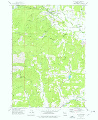
 1974 Laurel Mtn1977 Print · USGSIn the mid-1970s, the timberlands of Polk County were a complex network of industrial forest roads and high-elevation peaks. Researchers can trace the transition from early logging infrastructure at the Boulder Camp (Site) to the Old RR Grade and the George T Gerlinger State Experimental Forest.
 - 1974 Map of Valsetz, 1977 Print
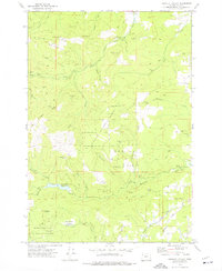
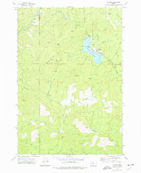 1974 Valsetz1977 Print · USGSIn the mid-seventies, the timber town of Valsetz remained a focal point of Oregon's Coast Range before its eventual removal. Researchers can trace the layout of the town and locate the former locations of Western Camp and the Fish Ladder along the Siletz River.
 - 1975 Map of Salem West, 1980 Print
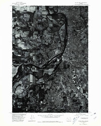 1975 Salem West1980 Print · USGSMid-century development and the winding river corridor define this 1975 aerial survey of the Marion County area. Local historians can trace the growth of Salem and the residential patterns of Liberty through these detailed orthophotograph images.
 - 1979 Map of Midway
 1979 Midway1979 Print · USGSCoastal mountains and timberlands meet in the late seventies where Yamhill, Tillamook, Lincoln, and Polk counties converge. Researchers can locate the Church in the Wildwood, trace the Nestucca River, and find small settlements like Midway and Boyer.
 - 1979 Map of Grand Ronde
 1979 Grand Ronde1979 Print · USGSGrand Ronde and the surrounding valley floor appear in the late 1970s as a hub of river-fronting industry and timber activity. Genealogists and researchers can trace the Longview Portland and Northern rail line, identify the Holmes Cem, and locate the Grand Ronde Agency at a turning point in the region's development.2 unique versions available
End of results
Showing maps 1-14 of 14
Top cities of Polk County
- Dallas historical maps
- Monmouth historical maps
- Independence historical maps
- Falls City historical maps
- Rickreall historical maps
Frequently asked questions
- What are the different types of historical maps available for Polk County?
- What is the oldest map of Polk County?
- Where can I purchase historical maps of Polk County for my home or office?
- Where can I download high-res historical maps of Polk County?
- Are there historical topographic maps available for Polk County?
- Is there historical aerial imagery available for Polk County?
- Where are historical maps of Polk County sourced from?