1970s Maps of Falls City, Oregon
Explore 2 historic maps of Falls City from the 1970s. These maps offer a rare glimpse into what life looked like during the 1970s — showing old roads, neighborhoods, homes, and landmarks that have changed or disappeared over time.
Whether you're researching your family's past, planning a metal detecting trip, or studying how Falls City's landscape evolved across the 1970s, these high-resolution maps are a powerful tool for exploring the history of this region.
- Focus on a specific era: All maps on this page are from the 1970s, giving you a focused view of this time period.
- See what’s changed: Compare century-old streets, trails, and buildings to today's modern landscape using overlays and satellite layers.
- Research with precision: Use these maps for genealogy, historical research, land use analysis, or educational projects.
- View, download, or print: Maps are fully viewable online in high resolution, and can be downloaded or printed for your own records.
Start exploring Falls City's history through authentic maps from the 1970s. This is your window into the past.
Falls City, OR maps
(2)- 1973 Map of Socialist Valley, 1977 Print
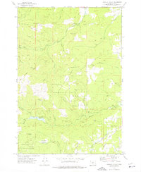 1973 Socialist Valley1977 Print · USGSThe timberlands and watersheds of Polk County come into focus in the early seventies. Genealogists and local historians can trace the Old German Brethren Ch, the Socialist Valley settlement, and the Aaron Mercer Reservoir.
 - 1974 Map of Falls City, 1977 Print
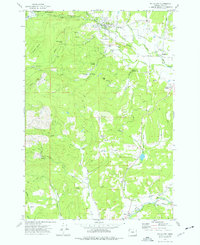 1974 Falls City1977 Print · USGSThe Luckiamute River valley in Polk County is captured here in the mid-1970s, showcasing a landscape of timber management and small riverfront settlements. Genealogists and historians can locate legacy sites like Odd Fellows Cem, Oakhurst School, and the Old Railroad Grade.
End of results
Showing maps 1-2 of 2
Top cities near Falls City
- Dallas historical maps
- Monmouth historical maps
- Independence historical maps
- Sheridan historical maps
- Willamina historical maps
- Adair Village historical maps
See more
Frequently asked questions
- What are the different types of historical maps available for Falls City?
- What is the oldest map of Falls City?
- Where can I purchase historical maps of Falls City for my home or office?
- Where can I download high-res historical maps of Falls City?
- Are there historical topographic maps available for Falls City?
- Is there historical aerial imagery available for Falls City?
- Where are historical maps of Falls City sourced from?