1960s Maps of Hermiston, Oregon
Explore 2 historic maps of Hermiston from the 1960s. These maps offer a rare glimpse into what life looked like during the 1960s — showing old roads, neighborhoods, homes, and landmarks that have changed or disappeared over time.
Whether you're researching your family's past, planning a metal detecting trip, or studying how Hermiston's landscape evolved across the 1960s, these high-resolution maps are a powerful tool for exploring the history of this region.
- Focus on a specific era: All maps on this page are from the 1960s, giving you a focused view of this time period.
- See what’s changed: Compare century-old streets, trails, and buildings to today's modern landscape using overlays and satellite layers.
- Research with precision: Use these maps for genealogy, historical research, land use analysis, or educational projects.
- View, download, or print: Maps are fully viewable online in high resolution, and can be downloaded or printed for your own records.
Start exploring Hermiston's history through authentic maps from the 1960s. This is your window into the past.
Hermiston, OR maps
(2)- 1962 Map of Stanfield, 1963 Print
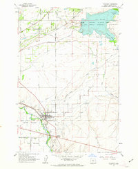 1962 Stanfield1963 Print · USGSUmatilla County agricultural life thrives in the early sixties along the vital Union Pacific rail line and river meadows. Genealogists and local historians can trace irrigation networks like the Furnish Ditch and locate early community sites including West Stanfield Sch and Pleasant View Cem.2 unique versions available
 - 1962 Map of Hermiston, 1963 Print
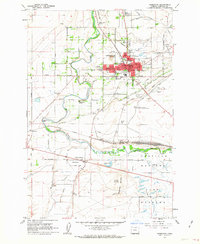 1962 Hermiston1963 Print · USGSHermiston and its surrounding irrigation district thrived in the early sixties as a hub of agriculture and rail transport. Genealogists and local historians can trace family-named roads like Cooney Lane, explore the rail yard at Hinkle, or locate rural landmarks like Bucks Corners.4 unique versions available
End of results
Showing maps 1-2 of 2
Top cities near Hermiston
Frequently asked questions
- What are the different types of historical maps available for Hermiston?
- What is the oldest map of Hermiston?
- Where can I purchase historical maps of Hermiston for my home or office?
- Where can I download high-res historical maps of Hermiston?
- Are there historical topographic maps available for Hermiston?
- Is there historical aerial imagery available for Hermiston?
- Where are historical maps of Hermiston sourced from?