1900s (20th Century) Maps of Summerville, Oregon
Explore 11 historic maps of Summerville from the 1900s (20th Century). These maps offer a rare glimpse into what life looked like during the 1900s — showing old roads, neighborhoods, homes, and landmarks that have changed or disappeared over time.
Whether you're researching your family's past, planning a metal detecting trip, or studying how Summerville's landscape evolved across the 1900s, these high-resolution maps are a powerful tool for exploring the history of this region.
- Focus on a specific era: All maps on this page are from the 1900s, giving you a focused view of this time period.
- See what’s changed: Compare century-old streets, trails, and buildings to today's modern landscape using overlays and satellite layers.
- Research with precision: Use these maps for genealogy, historical research, land use analysis, or educational projects.
- View, download, or print: Maps are fully viewable online in high resolution, and can be downloaded or printed for your own records.
Start exploring Summerville's history through authentic maps from the 1900s. This is your window into the past.
Summerville, OR maps
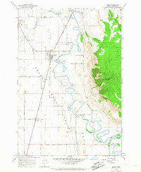
(11)- 1906 Map of Telocaset
 1906 Telocaset1906 Print · USGSEastern Oregon at the peak of its railroad and ranching era features a landscape of thriving valley towns and high forest reserves. Genealogists and local historians can trace early settlements like Union and Cove, or locate long-standing landmarks such as Hot Lake and Medical Springs.3 unique versions available
 - 1953 Map of Pendleton, 1957 Print
 1953 Pendleton1957 Print · USGSNortheastern Oregon and the Columbia River frontier are captured here in the early fifties, a time of massive federal infrastructure projects. Researchers can trace the historic route of The Old Oregon Trail as it passes near the Umatilla Ordnance Depot and the new McNary Dam.4 unique versions available
 - 1955 Map of Grangeville, 1964 Print
 1955 Grangeville1964 Print · USGSThe high country of the Idaho-Oregon border comes alive in the mid-1950s, showing the deep river canyons and mountain peaks. Trace the Union Pacific RR through the valleys or locate settlements like Grangeville, Joseph, and the shoreline of Wallowa Lake.4 unique versions available
 - 1956 Map of Pendleton
 1956 Pendleton1956 Print · USGSNortheastern Oregon’s high plateau and timbered peaks appear here in the mid-fifties, during a time of major military and hydroelectric development. Trace the path of The Old Oregon Trail alongside modern landmarks like McNary Dam and the Umatilla Ordnance Depot.
 - 1959 Map of Grangeville
 1959 Grangeville1959 Print · USGSThe high alpine peaks and deep river canyons of the Idaho-Oregon borderlands are captured in the late fifties. Researchers can trace the Union Pacific RR through the valleys to settlements like Enterprise, Union, and Grangeville.2 unique versions available
 - 1963 Map of Summerville, 1966 Print
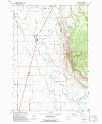
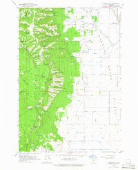 1963 Summerville1966 Print · USGSThe Grande Ronde Valley and the Blue Mountains meet in this Oregon study from the early sixties. Researchers can trace the area's rural development through the Pioneer Monument, the Grange Hall, and high-altitude landmarks like the Mt Emily Lookout Tower.2 unique versions available
 - 1965 Map of Imbler, 1967 Print
 1965 Imbler1967 Print · USGSThe Grande Ronde Valley in the 1960s was a landscape defined by the winding Grande Ronde River and the vital Union Pacific rail line. Researchers can trace the layout of small farming communities like Summerville, Imbler, and Alicel, alongside family-named landmarks like Gaskell Lane.2 unique versions available
 - 1979 Map of La Grande, 1980 Print
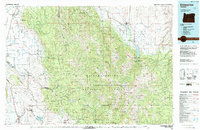
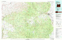 1979 La Grande1980 Print · USGSNorthwestern Oregon’s mountain corridors are captured here in the late seventies, showing the rail and river networks through the Blue Mountains. Trace the Old Emigrant Road, locate the Aurelia Mine, or explore the Starkey Experimental Forest.2 unique versions available
 - 1986 Map of Enterprise, 1987 Print
 1986 Enterprise1987 Print · USGSThe high peaks and deep valleys of Northeast Oregon are captured in the mid-1980s, showcasing the transition from the Grande Ronde Valley to the wilderness. Researchers can trace the Union Pacific rail corridor through Telocaset or locate historic sites like Cornucopia and Medical Springs.
 - 1994 Map of Imbler
 1994 Imbler1994 Print · USGSSettlement in the Grande Ronde Valley was well-established by the late twentieth century, centered on farming hubs and river management. Researchers can trace family history through the Summerville Cem or explore the rural development around Imbler, Rhinehart, and Alicel.
 - 1996 Map of Summerville, 1998 Print
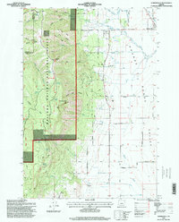 1996 Summerville1998 Print · USGSNortheastern Oregon's agricultural heartland meets the timbered uplands in the mid-nineties. Researchers can trace family ranch lands along Mc Kenzie Lane or locate landmarks like the Pleasant Grove Grange Hall and the Pioneer Monument.
End of results
Showing maps 1-11 of 11
Top cities near Summerville
- La Grande historical maps
- Elgin historical maps
- Island City historical maps
- Cove historical maps
- Imbler historical maps
Frequently asked questions
- What are the different types of historical maps available for Summerville?
- What is the oldest map of Summerville?
- Where can I purchase historical maps of Summerville for my home or office?
- Where can I download high-res historical maps of Summerville?
- Are there historical topographic maps available for Summerville?
- Is there historical aerial imagery available for Summerville?
- Where are historical maps of Summerville sourced from?