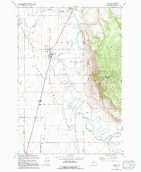
1994 Map of Imbler
USGS Topo · Published 1994About this map
The agricultural valleys of Union County are anchored by the Grande Ronde River, which carves a winding path past the foothills of Mount Harris. This 1994 edition reveals a landscape defined by an intricate network of rural roads such as Sandridge Road and Imbler Road, serving the small farming communities of Imbler, Summerville, and Alicel. The river's original oxbows are visible alongside the engineered State Ditch, a testament to local efforts to manage the floodplain for cultivation. Family-named landmarks and infrastructure like Speckhart Lane and various Storage Bins underscore the area's deep-rooted agrarian economy. To the northwest, the settlement of Summerville is located near its namesake Summerville Cem and a historic Mill site on Willow Creek. The steep eastern ascent toward the Lookout Radio Tower provides a sharp contrast to the flat, irrigated valley floor where the Grande Ronde meanders.
Find a feature on this map
35 named features on this map. Tap any name to fly to it.
Don’t see what you’re looking for? This feature index may not catch every label — zoom into the map to look around manually.
Map Details
Editions of this 1994 Imbler Map
This is the sole edition of this map. No revisions or reprints were ever made.
Other maps of this area

1906 · Telocaset
USGS Topo · 1:125,000

1953 · Pendleton
USGS Topo · 1:250,000

1955 · Grangeville
USGS Topo · 1:250,000

1956 · Pendleton
USGS Topo · 1:250,000

1959 · Grangeville
USGS Topo · 1:250,000

1963 · La Grande SE
USGS Topo · 1:24,000

1963 · Sanderson Spring
USGS Topo · 1:24,000

1963 · Summerville
USGS Topo · 1:24,000

1964 · Cricket Flat
USGS Topo · 1:24,000

1964 · Elgin
USGS Topo · 1:24,000