
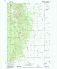
1963 Map of Summerville
USGS Topo · Published 1966About this map
The Grande Ronde Valley meets the rising timbered slopes of the Blue Mountains on this mid-century survey of northeastern Oregon. The community of Summerville sits at the edge of the flat valley floor, where an intricate network of rural roads like Glenn Road and Woodell Lane serve the agricultural landscape. To the west, the terrain rises sharply into the Umatilla National Forest and Whitman National Forest, defined by a sequence of prominent ridges such as Herron Ridge and Frizzell Ridge. At the summit of Mt Emily, a Lookout Tower overlooks the canyons below, including the evocatively named Fiddlers Hell. This map records the transition between the irrigated valley floor, marked by the Ordell Ditch, and the high-elevation forests dotted with vital water sources like Telephone Spring and Crystal Spring, essential for the region's logging and grazing history.
Find a feature on this map
64 named features on this map. Tap any name to fly to it.
Don’t see what you’re looking for? This feature index may not catch every label — zoom into the map to look around manually.
Map Details
Editions of this 1963 Summerville Map
2 editions found
Other maps of this area

1906 · Telocaset
USGS Topo · 1:125,000

1953 · Pendleton
USGS Topo · 1:250,000

1955 · Grangeville
USGS Topo · 1:250,000

1956 · Pendleton
USGS Topo · 1:250,000

1959 · Grangeville
USGS Topo · 1:250,000

1963 · La Grande SE
USGS Topo · 1:24,000

1963 · Sanderson Spring
USGS Topo · 1:24,000

1963 · Hilgard
USGS Topo · 1:24,000

1964 · Thimbleberry Mtn
USGS Topo · 1:24,000

1964 · Elgin
USGS Topo · 1:24,000