
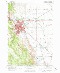
1963 Map of La Grande SE
USGS Topo · Published 1965About this map
La Grande and the surrounding Grande Ronde Valley are defined by the meeting of the Union Pacific railroad and the winding Grande Ronde River. This 1963 survey shows the city during a period of institutional growth, anchored by Eastern Oregon College and the Grande Ronde Hospital. The urban grid transitions quickly into the fertile lowlands of Island City, where a complex network of sloughs, including Gekeler Slough and Pierce Slough, dominates the drainage pattern.
Find a feature on this map
71 named features on this map. Tap any name to fly to it.
Don’t see what you’re looking for? This feature index may not catch every label — zoom into the map to look around manually.
Map Details
Editions of this 1963 La Grande SE Map
2 editions found
Other maps of this area

1906 · Telocaset
USGS Topo · 1:125,000

1953 · Pendleton
USGS Topo · 1:250,000

1955 · Grangeville
USGS Topo · 1:250,000

1956 · Pendleton
USGS Topo · 1:250,000

1959 · Grangeville
USGS Topo · 1:250,000

1963 · Hilgard
USGS Topo · 1:24,000

1963 · Summerville
USGS Topo · 1:24,000

1964 · Drumhill Ridge
USGS Topo · 1:24,000

1965 · Conley
USGS Topo · 1:24,000
1965 · Glass Hill
USGS Topo · 1:24,000