
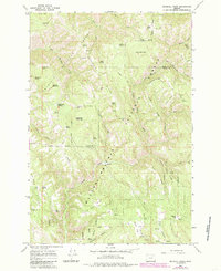
1964 Map of Drumhill Ridge
USGS Topo · Published 1966About this map
The high ridges of the Umatilla National Forest define this landscape along the county line between Umatilla and Union in the mid-1960s. The area is characterized by a dense network of mountain springs and forestry outposts, including the Summit Guard Station and established camps like Camp Three and Camp One. The terrain is marked by prominent landforms such as Drumhill Ridge, Telephone Ridge, and Sugarloaf Mountain, with numerous named water sources like Sacajawea Spring and Hoskins Spring feeding into Five Points Creek and Meacham Creek. A series of canyons and flats, notably Dixie Flat and Rocky Flat, break the steep slopes, while a jeep trail provides access to remote points like Kellers Cabin. The distribution of springs and cabins across these ridges suggests a landscape focused on forest management and seasonal livestock grazing, typical of the Blue Mountains region before modernization intensified.
Find a feature on this map
56 named features on this map. Tap any name to fly to it.
Don’t see what you’re looking for? This feature index may not catch every label — zoom into the map to look around manually.
Map Details
Editions of this 1964 Drumhill Ridge Map
2 editions found
Other maps of this area

1953 · Pendleton
USGS Topo · 1:250,000

1956 · Pendleton
USGS Topo · 1:250,000

1963 · La Grande SE
USGS Topo · 1:24,000

1963 · Sanderson Spring
USGS Topo · 1:24,000

1963 · Hilgard
USGS Topo · 1:24,000

1963 · Summerville
USGS Topo · 1:24,000

1964 · Duncan
USGS Topo · 1:24,000

1964 · Thimbleberry Mtn
USGS Topo · 1:24,000

1964 · Huron
USGS Topo · 1:24,000

1964 · Kamela SE
USGS Topo · 1:24,000