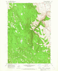
1965 Map of Glass Hill
USGS Topo · Published 1967About this map
Whitman National Forest dominates this mid-1960s landscape, where high ridgelines and steep drainages define the timbered terrain south of La Grande. The area is marked by working land and remote outposts, including the Reinecke Cabin and Vincent Ranch, which signal the local history of ranching and forest management. High points like Tamarack Mountain and the prominent Glass Hill summit—complete with its Lookout Tower—provide vantage points over the complex system of creeks including Beaver Creek and Ladd Creek. In the northeast corner, the Ladd Marsh Game Management Area indicates the transition from the high Summit Spring Ridge toward the valley floor. Transportation is limited to rugged routes like Glass Hill Road and Ladd Lane, alongside a major Pipeline corridor cutting through the northern foothills.
Find a feature on this map
30 named features on this map. Tap any name to fly to it.
Don’t see what you’re looking for? This feature index may not catch every label — zoom into the map to look around manually.
Map Details
Editions of this 1965 Glass Hill Map
2 editions found
Other maps of this area

1906 · Telocaset
USGS Topo · 1:125,000

1953 · Pendleton
USGS Topo · 1:250,000

1955 · Grangeville
USGS Topo · 1:250,000

1956 · Pendleton
USGS Topo · 1:250,000

1959 · Grangeville
USGS Topo · 1:250,000

1963 · La Grande SE
USGS Topo · 1:24,000

1963 · Hilgard
USGS Topo · 1:24,000

1965 · Anthony Butte
USGS Topo · 1:24,000

1965 · Conley
USGS Topo · 1:24,000
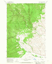
1965 · Tucker Flat
USGS Topo · 1:24,000