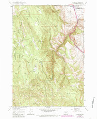
1965 Map of Glass Hill
USGS Topo · Published 1985About this map
Whitman National Forest dominates the southern reaches of this landscape, where the high terrain of Tamarack Mountain and Summit Ridge drops into the complex drainage systems of Clear Creek and Ladd Canyon. The map documents a mid-century transitional environment, showing the intersection of conservation and utility through features like the Glass Hill Lookout Tower and a nearby Radio Facility.
Find a feature on this map
38 named features on this map. Tap any name to fly to it.
Don’t see what you’re looking for? This feature index may not catch every label — zoom into the map to look around manually.
Map Details
Editions of this 1965 Glass Hill Map
2 editions found
Other maps of this area

1906 · Telocaset
USGS Topo · 1:125,000

1953 · Pendleton
USGS Topo · 1:250,000

1955 · Grangeville
USGS Topo · 1:250,000

1956 · Pendleton
USGS Topo · 1:250,000

1959 · Grangeville
USGS Topo · 1:250,000

1963 · La Grande SE
USGS Topo · 1:24,000

1963 · Hilgard
USGS Topo · 1:24,000

1965 · Anthony Butte
USGS Topo · 1:24,000

1965 · Conley
USGS Topo · 1:24,000
1965 · Glass Hill
USGS Topo · 1:24,000