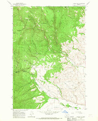
1965 Map of Tucker Flat
USGS Topo · Published 1967About this map
The Whitman National Forest dominates this mid-1960s landscape, where the boundary between Union Co and Baker Co runs through a complex network of drainages and timbered ridges. Industrial history is evident at the China Diggings (Site) and scattered prospects, suggesting the area's legacy of resource extraction. The terrain is defined by prominent features like Mann Ridge, Summit Ridge, and Red Ridge, which channel numerous waterways including Wolf Creek and Pilcher Creek toward the North Powder River in the North Powder Valley. A system of man-made infrastructure, including a flume and various ditches, highlights the historic management of water across Tucker Flat. This survey provides a clear look at the primitive transportation network of the era, consisting primarily of a jeep trail connecting remote locations like Hunter Camp and various springs.
Find a feature on this map
33 named features on this map. Tap any name to fly to it.
Don’t see what you’re looking for? This feature index may not catch every label — zoom into the map to look around manually.
Map Details
Editions of this 1965 Tucker Flat Map
2 editions found
Other maps of this area

1901 · Baker City
USGS Topo · 1:125,000

1901 · Sumpter
USGS Topo · 1:125,000

1906 · Telocaset
USGS Topo · 1:125,000

1953 · Pendleton
USGS Topo · 1:250,000

1955 · Baker
USGS Topo · 1:250,000

1955 · Grangeville
USGS Topo · 1:250,000

1955 · Canyon City
USGS Topo · 1:250,000

1956 · Pendleton
USGS Topo · 1:250,000

1959 · Baker
USGS Topo · 1:250,000

1959 · Grangeville
USGS Topo · 1:250,000