1930s Maps of Wasco County, Oregon
Explore 5 historic maps of Wasco County from the 1930s. These maps offer a rare glimpse into what life looked like during the 1930s — showing old roads, neighborhoods, homes, and landmarks that have changed or disappeared over time.
Whether you're researching your family's past, planning a metal detecting trip, or studying how Wasco County's landscape evolved across the 1930s, these high-resolution maps are a powerful tool for exploring the history of this region.
- Focus on a specific era: All maps on this page are from the 1930s, giving you a focused view of this time period.
- See what’s changed: Compare century-old streets, trails, and buildings to today's modern landscape using overlays and satellite layers.
- Research with precision: Use these maps for genealogy, historical research, land use analysis, or educational projects.
- View, download, or print: Maps are fully viewable online in high resolution, and can be downloaded or printed for your own records.
Start exploring Wasco County's history through authentic maps from the 1930s. This is your window into the past.
Wasco County, OR maps
(5)- 1930 Map of Mt. Jefferson
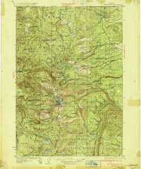 1930 Mt. Jefferson1930 Print · USGSThe Oregon Cascades were a frontier of early forest management and tribal lands during the late 1920s. Researchers can locate remote administrative outposts like the Lemiti Ranger Sta, trace the thermal waters of Breitenbush Hot Sprs, and explore the high meadows of Independence Prairie.3 unique versions available
 - 1930 Map of Dufur, 1945 Print
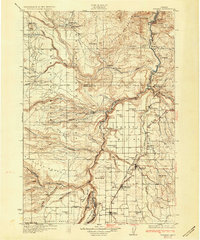
 1930 Dufur1945 Print · USGSWasco County at the start of the 1930s shows a transition from pioneer wagon routes to a rail-and-ranch economy. Genealogists can locate dozens of country schools like Ireland Sch and early infrastructure including the Barlow Road and the Great Southern Railroad.2 unique versions available
 - 1931 Map of Madras
 1931 Madras1931 Print · USGSCentral Oregon ranching and rail life come into focus in the late twenties, centering on the Warm Springs Agency. Trace the river-level rail stops at Mecca and Kaskela or locate early rural schoolhouses like New Era Sch and Lyle Gap Sch.2 unique versions available
 - 1934 Map of Dufur
 1934 Dufur1934 Print · USGSWasco County during the mid-1930s reveals a landscape of high plateaus and river canyons shaped by pioneering roads and rail. Genealogists can trace family roots through a dense network of rural schoolhouses like Kelly Sch and Wolf Run Sch, or follow the path of the historic Barlow Road.2 unique versions available
 - 1934 Map of The Dalles
 1934 The Dalles1934 Print · USGSThe Columbia River Gorge in the early thirties reveals a complex network of rapids and river engineering before the completion of major modern dams. Local historians can trace early school districts like Threemile Sch and family landmarks such as Clancy Ranch or Petersburg.4 unique versions available
End of results
Showing maps 1-5 of 5
Top cities of Wasco County
- The Dalles historical maps
- Chenowith historical maps
- Dufur historical maps
- Maupin historical maps
- Mosier historical maps
- Antelope historical maps
See more
Frequently asked questions
- What are the different types of historical maps available for Wasco County?
- What is the oldest map of Wasco County?
- Where can I purchase historical maps of Wasco County for my home or office?
- Where can I download high-res historical maps of Wasco County?
- Are there historical topographic maps available for Wasco County?
- Is there historical aerial imagery available for Wasco County?
- Where are historical maps of Wasco County sourced from?