1900s (20th Century) Maps of Washington County, Oregon
Explore 88 historic maps of Washington County from the 1900s (20th Century). These maps offer a rare glimpse into what life looked like during the 1900s — showing old roads, neighborhoods, homes, and landmarks that have changed or disappeared over time.
Whether you're researching your family's past, planning a metal detecting trip, or studying how Washington County's landscape evolved across the 1900s, these high-resolution maps are a powerful tool for exploring the history of this region.
- Focus on a specific era: All maps on this page are from the 1900s, giving you a focused view of this time period.
- See what’s changed: Compare century-old streets, trails, and buildings to today's modern landscape using overlays and satellite layers.
- Research with precision: Use these maps for genealogy, historical research, land use analysis, or educational projects.
- View, download, or print: Maps are fully viewable online in high resolution, and can be downloaded or printed for your own records.
Start exploring Washington County's history through authentic maps from the 1900s. This is your window into the past.
Washington County, OR maps
(88)- 1905 Map of Portland
 1905 Portland1905 Print · USGSGreater Portland and Vancouver are seen here during the era of the Lewis and Clark Exposition, when river traffic and early electric rail lines defined the region. Researchers can locate the Lewis and Clark Centennial Exposition, the historic Vancouver Barracks, and Munday's Ferry.8 unique versions available
 - 1914 Map of Oregon City
 1914 Oregon City1914 Print · USGSThe Willamette Valley at the start of the twentieth century was a landscape of rapid rail expansion and river-based industry. Researchers can trace early rural life through Wichita School and Lions Mill, or explore the growth of Oswego and Milwaukie.4 unique versions available
 - 1915 Map of Hillsboro
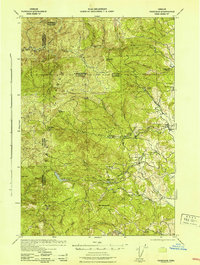
 1915 Hillsboro1915 Print · USGSThe Tualatin Valley and the confluence of the Columbia and Willamette rivers are shown here at the peak of the electric rail era. Researchers can trace historic family schoolhouses like Mason Hill School and vanished landings such as Blurock Landing.
 - 1916 Map of Tualatin
 1916 Tualatin1916 Print · USGSThe northern Willamette Valley in the mid-1910s is a landscape of orchards and rail spurs, where river ferries still compete with new electric lines. Trace family roots at Champoeg Monument or explore old school sites like Grabel School and St Pauls School.5 unique versions available
 - 1918 Map of Hillsboro
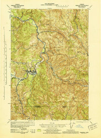
 1918 Hillsboro1918 Print · USGSThe Tualatin Valley and Columbia riverfront are seen here during the heyday of the electric interurban and steam rail era. Researchers can trace family sites at Mason Hill School, identify the river life of Sauvie Island, or locate vanished stops like Cornelius Pass.4 unique versions available
 - 1922 Map of St. Helens
 1922 St. Helens1922 Print · USGSThe Columbia River valley in the early twenties was a hub of logging and river commerce. Genealogists can trace family roots through old post offices like Yankton P.O. and Warren P.O. or locate historic industry at the Dupont Powder Co. site.
 - 1939 Map of Oregon City, 1958 Print
 1939 Oregon City1958 Print · USGSThe Willamette Valley during the late thirties shows a landscape defined by river industry and competing rail lines. Genealogists and historians can trace family-named sites and rural institutions like the Ten O'clock Church, Linns Mill, and Reed College.
 - 1939 Map of Tualatin, 1958 Print
 1939 Tualatin1958 Print · USGSThe Tualatin Valley and Willamette River corridor are captured here before mid-century growth transformed the region. Genealogists can trace family footprints through dozens of rural landmarks, from Miners Landing and Butteville Sta to Mountainside School.
 - 1940 Map of Tualatin
 1940 Tualatin1940 Print · USGSThe Tualatin Valley comes into sharp focus during the late 1930s, showing the early footprints of Beaverton and Tigard amid a vast network of rail lines. Researchers can trace historic family schoolhouses like Witch Hazel School and locate the original path of Boones Ferry Road near Wilsonville.
 - 1940 Map of Hillsboro
 1940 Hillsboro1940 Print · USGSThe Tualatin Valley and the Columbia River confluence meet in this 1940 survey of the Hillsboro and North Portland region. Researchers can trace early twentieth-century rail lines like the Oregon Electric or locate historic rural landmarks such as Mountain View Cemetery and the Mason Hill School.
 - 1940 Map of Portland
 1940 Portland1940 Print · USGSThe Portland and Vancouver riverfronts are captured here just before the massive industrial shifts of the mid-century. Genealogists and historians can locate early landmarks like Vancouver Barracks, the University of Portland, and Mundays Ferry.4 unique versions available
 - 1940 Map of Vernonia, 1941 Print
 1940 Vernonia1941 Print · USGSNorthwestern Oregon’s timber country comes into focus in this 1940 survey, showing the river-valley settlements just before the Second World War. Researchers can trace early rural life through landmarks like Pleasant Hill School, the town of Vernonia, and the Catherwood Lookout.
 - 1941 Map of Keasey
 1941 Keasey1941 Print · USGSThe timber and rail economy of northwest Oregon is captured here just before the war. Trace the path of the Oregon American Lumber Co railroad and locate family landmarks like A W Nelsons Farm and the Winema Sch.
 - 1941 Map of St Helens
 1941 St Helens1941 Print · USGSThe Columbia River waterfront near St. Helens was a thriving industrial and agricultural corridor just before the war. Trace old rail stops at Honeymoon Sta, rural schoolhouses like Shilo Basin Sch, and the shifting river islands from Deer Island to Bachelor Island.
 - 1941 Map of Timber
 1941 Timber1941 Print · USGSCoastal Oregon at the start of the 1940s reveals a landscape defined by timber extraction and railroad expansion. Genealogists and historians can trace the remote logging life through Timber, Cochran, and numerous work sites like the Gonnacher Logging Camp.
 - 1941 Map of Oregon City
 1941 Oregon City1941 Print · USGSThe Lower Willamette Valley thrived on a mix of river power and rail transit in the early 1940s. Genealogists can trace family footprints across dozens of local school districts, from Petes Mountain School to Harmony School, and locate landmarks like Willamette Falls and the Ten O'clock Church.
 - 1941 Map of Gales Creek
 1941 Gales Creek1941 Print · USGSWashington County at the start of the 1940s reveals a landscape of logging camps and rural schoolhouses. Genealogists can trace family roots at the Kansas City School and Watts School or locate early industrial sites like the F W Dixon Lumber Mill.
 - 1941 Map of Yamhill, 1963 Print
 1941 Yamhill1963 Print · USGSThe northern Willamette Valley and Tualatin hills come alive in this wartime-era survey of the Yamhill and Washington county border. Genealogists and historians can trace defunct school districts like White Cloud Sch, the sprawling Stimson Lumber Camp, and the tracks of the Southern Pacific.2 unique versions available
 - 1942 Map of Yamhill
 1942 Yamhill1942 Print · USGSThe timber and rail corridors of the Tualatin Valley come alive in this wartime portrait of Yamhill and Washington Counties. Genealogists and researchers can trace rural school districts like Firdale Sch and Pioneer Sch or locate the Stimson Lumber Camp and Laurelwood Academy.
 - 1942 Map of Fairdale
 1942 Fairdale1942 Print · USGSThe Coast Range timber and water infrastructure are in full focus during the early years of the war. Researchers can locate the Fairdale C C C Camp, trace local education at the High Heaven Sch, and identify mountain landmarks like the Trask Mtn Lookout.
 - 1943 Map of Vernonia
 1943 Vernonia1943 Print · USGSUpper Nehalem Valley life in the early 1940s is defined here by the logging railways and riverside hamlets of Columbia County. You can trace the United Railways line into Vernonia or locate vanished rural schoolhouses like Beaver Creek Sch and Natal Sch.
 - 1943 Map of Keasey
 1943 Keasey1943 Print · USGSThe timber country of the northern Oregon Coast Range comes alive in the early 1940s as loggers worked the Nehalem River basin. Researchers can trace the industrial footprint of the Oregon American Lumber Company and find small outposts like Birkenfeld, Keasey, and Neverstill.
 - 1943 Map of St Helens
 1943 St Helens1943 Print · USGSThe Columbia River corridor during the mid-forties shows a bustling network of riverfront towns and upland settlements. Researchers can trace historic river landings like Caples Landing alongside rural landmarks such as Yankton, Trenholm, and Shilo Basin Sch.
 - 1948 Map of Vancouver, 1957 Print
 1948 Vancouver1957 Print · USGSPost-war growth transforms the river valleys of the Pacific Northwest as the timber and rail economy thrives. Trace family roots in Tillamook or Oregon City, and locate vanished landmarks like the spit at Bayocean or the Skamania Mine.
 - 1950 Map of Vancouver
 1950 Vancouver1950 Print · USGSCoastal Oregon and the lower Columbia River valley are captured in detail just after the war. Researchers can trace historic rail routes like the Southern Pacific or locate early settlements such as Vernonia, Gaston, and the Grand Ronde Indian Reservation.
Showing maps 1-25 of 88
Top cities of Washington County
- Hillsboro historical maps
- Beaverton historical maps
- Tigard historical maps
- Tualatin historical maps
- Forest Grove historical maps
- Sherwood historical maps
See more
Frequently asked questions
- What are the different types of historical maps available for Washington County?
- What is the oldest map of Washington County?
- Where can I purchase historical maps of Washington County for my home or office?
- Where can I download high-res historical maps of Washington County?
- Are there historical topographic maps available for Washington County?
- Is there historical aerial imagery available for Washington County?
- Where are historical maps of Washington County sourced from?