1900s (20th Century) Maps of Beaverton, Oregon
Explore 38 historic maps of Beaverton from the 1900s (20th Century). These maps offer a rare glimpse into what life looked like during the 1900s — showing old roads, neighborhoods, homes, and landmarks that have changed or disappeared over time.
Whether you're researching your family's past, planning a metal detecting trip, or studying how Beaverton's landscape evolved across the 1900s, these high-resolution maps are a powerful tool for exploring the history of this region.
- Focus on a specific era: All maps on this page are from the 1900s, giving you a focused view of this time period.
- See what’s changed: Compare century-old streets, trails, and buildings to today's modern landscape using overlays and satellite layers.
- Research with precision: Use these maps for genealogy, historical research, land use analysis, or educational projects.
- View, download, or print: Maps are fully viewable online in high resolution, and can be downloaded or printed for your own records.
Start exploring Beaverton's history through authentic maps from the 1900s. This is your window into the past.
Beaverton, OR maps
(38)- 1905 Map of Portland
 1905 Portland1905 Print · USGSGreater Portland and Vancouver are seen here during the era of the Lewis and Clark Exposition, when river traffic and early electric rail lines defined the region. Researchers can locate the Lewis and Clark Centennial Exposition, the historic Vancouver Barracks, and Munday's Ferry.8 unique versions available
 - 1914 Map of Oregon City
 1914 Oregon City1914 Print · USGSThe Willamette Valley at the start of the twentieth century was a landscape of rapid rail expansion and river-based industry. Researchers can trace early rural life through Wichita School and Lions Mill, or explore the growth of Oswego and Milwaukie.4 unique versions available
 - 1915 Map of Hillsboro
 1915 Hillsboro1915 Print · USGSThe Tualatin Valley and the confluence of the Columbia and Willamette rivers are shown here at the peak of the electric rail era. Researchers can trace historic family schoolhouses like Mason Hill School and vanished landings such as Blurock Landing.
 - 1916 Map of Tualatin
 1916 Tualatin1916 Print · USGSThe northern Willamette Valley in the mid-1910s is a landscape of orchards and rail spurs, where river ferries still compete with new electric lines. Trace family roots at Champoeg Monument or explore old school sites like Grabel School and St Pauls School.5 unique versions available
 - 1918 Map of Hillsboro
 1918 Hillsboro1918 Print · USGSThe Tualatin Valley and Columbia riverfront are seen here during the heyday of the electric interurban and steam rail era. Researchers can trace family sites at Mason Hill School, identify the river life of Sauvie Island, or locate vanished stops like Cornelius Pass.4 unique versions available
 - 1939 Map of Oregon City, 1958 Print
 1939 Oregon City1958 Print · USGSThe Willamette Valley during the late thirties shows a landscape defined by river industry and competing rail lines. Genealogists and historians can trace family-named sites and rural institutions like the Ten O'clock Church, Linns Mill, and Reed College.
 - 1939 Map of Tualatin, 1958 Print
 1939 Tualatin1958 Print · USGSThe Tualatin Valley and Willamette River corridor are captured here before mid-century growth transformed the region. Genealogists can trace family footprints through dozens of rural landmarks, from Miners Landing and Butteville Sta to Mountainside School.
 - 1940 Map of Tualatin
 1940 Tualatin1940 Print · USGSThe Tualatin Valley comes into sharp focus during the late 1930s, showing the early footprints of Beaverton and Tigard amid a vast network of rail lines. Researchers can trace historic family schoolhouses like Witch Hazel School and locate the original path of Boones Ferry Road near Wilsonville.
 - 1940 Map of Hillsboro
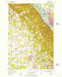
 1940 Hillsboro1940 Print · USGSThe Tualatin Valley and the Columbia River confluence meet in this 1940 survey of the Hillsboro and North Portland region. Researchers can trace early twentieth-century rail lines like the Oregon Electric or locate historic rural landmarks such as Mountain View Cemetery and the Mason Hill School.
 - 1940 Map of Portland
 1940 Portland1940 Print · USGSThe Portland and Vancouver riverfronts are captured here just before the massive industrial shifts of the mid-century. Genealogists and historians can locate early landmarks like Vancouver Barracks, the University of Portland, and Mundays Ferry.4 unique versions available
 - 1941 Map of Oregon City
 1941 Oregon City1941 Print · USGSThe Lower Willamette Valley thrived on a mix of river power and rail transit in the early 1940s. Genealogists can trace family footprints across dozens of local school districts, from Petes Mountain School to Harmony School, and locate landmarks like Willamette Falls and the Ten O'clock Church.
 - 1948 Map of Vancouver, 1957 Print
 1948 Vancouver1957 Print · USGSPost-war growth transforms the river valleys of the Pacific Northwest as the timber and rail economy thrives. Trace family roots in Tillamook or Oregon City, and locate vanished landmarks like the spit at Bayocean or the Skamania Mine.
 - 1950 Map of Vancouver
 1950 Vancouver1950 Print · USGSCoastal Oregon and the lower Columbia River valley are captured in detail just after the war. Researchers can trace historic rail routes like the Southern Pacific or locate early settlements such as Vernonia, Gaston, and the Grand Ronde Indian Reservation.
 - 1950 Map of Vancouver, 1951 Print
 1950 Vancouver1951 Print · USGSThe Pacific Northwest urban corridor meets the rugged coast in the years following the war, showing the expansion of Portland and Vancouver. Genealogists and historians can trace the reach of the Southern Pacific RR and locate coastal communities like Tillamook, Seaside, and Tolovana Park.
 - 1954 Map of Beaverton, 1956 Print
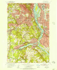
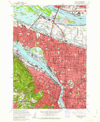
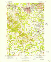 1954 Beaverton1956 Print · USGSMid-century Washington County reveals a growing suburban network just before its modern boom. Researchers can trace historic family landmarks such as Cooper Mtn Cem, old rail lines like the Oregon Electric, and established schools including Merle Davies Sch.
 - 1954 Map of Portland, 1956 Print
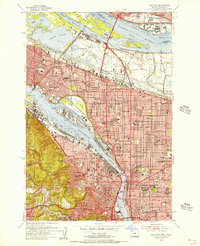 1954 Portland1956 Print · USGSMid-century Portland and Vancouver appear in high detail during an era of significant post-war industrial and urban transition. Genealogists and researchers can locate the Vanport City (Site), the Swan Island Shipyard, and many parish schools such as St Andrews Sch.
 - 1954 Map of Scholls, 1956 Print
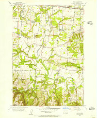 1954 Scholls1956 Print · USGSWashington County agricultural life is centered on the winding Tualatin River during the mid-fifties. Genealogists can trace family roots through sites like Pleasant Hill Cemetery, the Grange Hall, and several locations of abandoned schools.
 - 1954 Map of Linnton, 1957 Print
 1954 Linnton1957 Print · USGSThe Tualatin Mountains and the Willamette waterfront meet in this mid-century survey of the Portland area and its western suburbs. Genealogists and local historians can trace the growth of St Johns and Cedar Mill or locate family plots at Skyline Memorial Gardens.
 - 1954 Map of Oswego, 1957 Print
 1954 Oswego1957 Print · USGSSouthwest Portland and the Willamette valley were undergoing rapid suburban growth during the mid-fifties. Researchers can trace the development of neighborhoods like Hillsdale and Multnomah, or locate family sites near Reed College and Riverview Cemetery.
 - 1958 Map of Vancouver, 1968 Print
 1958 Vancouver1968 Print · USGSThe Lower Columbia and Willamette valleys thrive in the late sixties as major rail and river hubs. Genealogists and historians can trace the development of Portland, identify the grounds of Camp Withycombe, and locate coastal landmarks from Tillamook Head to Garibaldi.3 unique versions available
 - 1961 Map of Beaverton
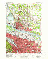
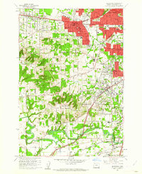 1961 Beaverton1961 Print · USGSBeaverton and Tigard are caught in a moment of post-war suburban expansion just as the rail-centered economy shifts toward the highway. Genealogists can locate family sites at Crescent Grove Cem or trace institutions like St Marys Boys Home and the Bernard Airport.5 unique versions available
 - 1961 Map of Scholls
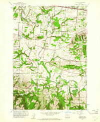 1961 Scholls1961 Print · USGSWashington County agriculture and river-valley life are captured here in the early sixties, as the region maintained its rural character. Genealogists and historians can trace family-named sites like Mountainside Cem, Witch Hazel School, and the community of Scholls.5 unique versions available
 - 1961 Map of Linnton
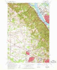 1961 Linnton1961 Print · USGSThe northern reaches of the Tualatin Valley and the Willamette riverfront meet here in the early sixties. Researchers can trace the expansion of suburban Cedar Mill and Aloha or locate historic sites like Union Cem and the St Johns Bridge.4 unique versions available
 - 1961 Map of Portland, 1962 Print
 1961 Portland1962 Print · USGSPortland and Vancouver are captured during a season of rapid postwar change, showing the city's growth along the river before modern freeway expansions. Researchers can trace family roots at Mt Calvary Cemetery or locate the historic Vanport City site.3 unique versions available
 - 1961 Map of Portland, 1963 Print
 1961 Portland1963 Print · USGSThe Columbia River waterfront and the growing suburbs of the early sixties come to life in this detailed survey of the Oregon-Washington border. Researchers can trace the legacy of Vanport City, find the St. Johns Cemetery, or locate the Fort Vancouver National Monument.3 unique versions available
Showing maps 1-25 of 38
Top cities near Beaverton
- Portland historical maps
- Vancouver historical maps
- Hillsboro historical maps
- Tigard historical maps
- Lake Oswego historical maps
- Oregon City historical maps
See more
Top neighborhoods of Beaverton
- Denney Whitford/Raleigh West historical maps
- Five Oaks/Triple Creek historical maps
- Central Beaverton historical maps
- Neighbors Southwest historical maps
- Vose historical maps
- South Beaverton historical maps
See more
Frequently asked questions
- What are the different types of historical maps available for Beaverton?
- What is the oldest map of Beaverton?
- Where can I purchase historical maps of Beaverton for my home or office?
- Where can I download high-res historical maps of Beaverton?
- Are there historical topographic maps available for Beaverton?
- Is there historical aerial imagery available for Beaverton?
- Where are historical maps of Beaverton sourced from?