1940s Maps of Athens Township, Pennsylvania
Explore 3 historic maps of Athens Township from the 1940s. These maps offer a rare glimpse into what life looked like during the 1940s — showing old roads, neighborhoods, homes, and landmarks that have changed or disappeared over time.
Whether you're researching your family's past, planning a metal detecting trip, or studying how Athens Township's landscape evolved across the 1940s, these high-resolution maps are a powerful tool for exploring the history of this region.
- Focus on a specific era: All maps on this page are from the 1940s, giving you a focused view of this time period.
- See what’s changed: Compare century-old streets, trails, and buildings to today's modern landscape using overlays and satellite layers.
- Research with precision: Use these maps for genealogy, historical research, land use analysis, or educational projects.
- View, download, or print: Maps are fully viewable online in high resolution, and can be downloaded or printed for your own records.
Start exploring Athens Township's history through authentic maps from the 1940s. This is your window into the past.
Athens Township, PA maps
(3)- 1942 Map of Sayre
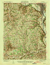 1942 Sayre1942 Print · USGSThe river confluence at Sayre and Athens stands as a major rail and industrial center in the years before the war. Family historians can trace rural roots through numerous upland landmarks like Harkness Cem, Riggs Ch, and the Doty Hill Sch.2 unique versions available
 - 1943 Map of Towanda, 1944 Print
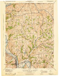 1943 Towanda1944 Print · USGSTowanda and the Susquehanna River valley are captured here during the mid-1940s, showing a landscape defined by river-rail transit and upland farming. Genealogists can locate dozens of country schools and churches, from Pine Grove Sch to the Bald Eagle Ch.
 - 1948 Map of Sayre
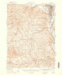 1948 Sayre1948 Print · USGSThe twin rivers of Bradford County meet in the late 1940s, defining a landscape shaped by the Lehigh Valley railroad and valley agriculture. Genealogists can trace early homesteads and landmarks like Harknessburg Cem, Doty Hill Sch, and Ridgebury Chapel.3 unique versions available
End of results
Showing maps 1-3 of 3
Top cities near Athens Township
- Elmira historical maps
- Horseheads historical maps
- Southport historical maps
- Barton historical maps
- Elmira historical maps
- Southport historical maps
See more
Top neighborhoods of Athens Township
- Wilawana historical maps
- East Athens historical maps
- Greens Landing historical maps
- West Athens historical maps
Frequently asked questions
- What are the different types of historical maps available for Athens Township?
- What is the oldest map of Athens Township?
- Where can I purchase historical maps of Athens Township for my home or office?
- Where can I download high-res historical maps of Athens Township?
- Are there historical topographic maps available for Athens Township?
- Is there historical aerial imagery available for Athens Township?
- Where are historical maps of Athens Township sourced from?