1950s Maps of Columbia Township, Pennsylvania
Explore 5 historic maps of Columbia Township from the 1950s. These maps offer a rare glimpse into what life looked like during the 1950s — showing old roads, neighborhoods, homes, and landmarks that have changed or disappeared over time.
Whether you're researching your family's past, planning a metal detecting trip, or studying how Columbia Township's landscape evolved across the 1950s, these high-resolution maps are a powerful tool for exploring the history of this region.
- Focus on a specific era: All maps on this page are from the 1950s, giving you a focused view of this time period.
- See what’s changed: Compare century-old streets, trails, and buildings to today's modern landscape using overlays and satellite layers.
- Research with precision: Use these maps for genealogy, historical research, land use analysis, or educational projects.
- View, download, or print: Maps are fully viewable online in high resolution, and can be downloaded or printed for your own records.
Start exploring Columbia Township's history through authentic maps from the 1950s. This is your window into the past.
Columbia Township, PA maps
(5)- 1953 Map of Roseville, 1954 Print
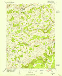 1953 Roseville1954 Print · USGSTioga and Bradford counties are captured here in the early 1950s, showing a landscape defined by upland farms and quiet crossroads. Researchers can trace ancestral roots at State Road Ch, find early settlements like Austinville, or follow the path of the Roosevelt Highway.2 unique versions available
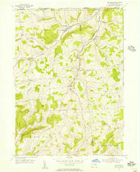
 - 1954 Map of Williamsport
 1954 Williamsport1954 Print · USGSNorth-central Pennsylvania in the mid-fifties is defined by the winding West Branch Susquehanna River and its industrial valley. Local historians can trace the massive Susquehanna Ordnance Depot and the extensive rail networks of the Pennsylvania Railroad.
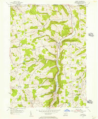
 - 1954 Map of Millerton, 1956 Print
 1954 Millerton1956 Print · USGSTioga County farming communities thrive along the New York border in the mid-fifties, before modern development altered these rural corridors. Researchers can trace family roots at West Jackson Ch or locate vanished homesteads near Pumpkin Hill Cem and Sopertown.4 unique versions available
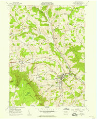
 - 1954 Map of Gillett, 1956 Print
 1954 Gillett1956 Print · USGSNorthern Bradford County's valley farms and rail sidings are frozen in time during the mid-fifties. Researchers can trace family-named landmarks and rural congregations like Baptist Hill Ch, Snedekerville, and the Doty Hill Cem along the PENNSYLVANIA railroad line.4 unique versions available
 - 1957 Map of Troy, 1958 Print
 1957 Troy1958 Print · USGSBradford County dairy and rail commerce center on the town of Troy during the mid-fifties. Genealogists can trace family names through numerous rural burial grounds like Sylvania Cem and Hunt Cem, or locate landmarks such as the Lloyd Sch and Austinville.2 unique versions available
End of results
Showing maps 1-5 of 5
Top cities near Columbia Township
- Southport historical maps
- Elmira historical maps
- Southport historical maps
- Mansfield historical maps
- Chemung historical maps
- Caton historical maps
See more
Top neighborhoods of Columbia Township
- Sopertown historical maps
- Austinville historical maps
- Columbia Cross Roads historical maps
- Snedekerville historical maps
Frequently asked questions
- What are the different types of historical maps available for Columbia Township?
- What is the oldest map of Columbia Township?
- Where can I purchase historical maps of Columbia Township for my home or office?
- Where can I download high-res historical maps of Columbia Township?
- Are there historical topographic maps available for Columbia Township?
- Is there historical aerial imagery available for Columbia Township?
- Where are historical maps of Columbia Township sourced from?